Archive for the ‘ROUTE MAPS’ Category
Route Map……Sausalito to Pt. Bonita Loop
Overall, this is an incredible 15-mile ride. The loop has views that tourists come from a world away to take-in; roads in very good condition with a bike shoulder for much of the way; and, interesting and varied terrain.
If this ride were a restaurant, it would earn a 3-star on the Michelin scale!
Beginning at sea level in downtown Sausalito and cresting at the top of the Marin Headlands near Hawk Hill, I was surprised the elevation gain was only 800 feet. It felt like much more. That’s barely a third of the way up Mt. Tam (elevation 2,571′)!
Here’s a map and elevation chart extracted from the gpx file created by the gps logging device I sometimes carry with me.
Route Map……SOMA to Sausalito
Here’s the specific route: 11.6 miles (as always, use the buttons to change the map type or zoom in or out)
On the Road……Sausalito to Fairfax (and back)
A pleasant ride on Sunday and some happenstance led to some encounters with several old and new friends.
I first met my buddy Steve, who I know from Berkeley grad school days. We casually pedaled, vaguely northward, chatting most of the way as we rode. After turning off Shady Lane in Ross and passing through San Anselmo we rode by The Bicycle Works. There we saw Jelani Bertoni, who was curbside, making preparations of some sort. He informed me that that afternoon there was a big party to celebrate the 3rd anniversary of this cool little non-profit.
Then another Bicycle Works star — Heather — stopped in on her bike at a yard sale Steve and I were checking out just on the edge of Fairfax.
And finally, a big shout out to Gino and his girlfriend Starla (of Teddergreen Bicycle Fitting Services). Gino and I had exchanged some emails, but had never actually met in person. However, these two were gracious enough to stop and say hello (after seeing my Ebisu on the side of the road) as they cruised south for some adventures out in the Marin Headlands.
In terms of the route, there are a few different options. But in my opinion, this is the best way to ride from Sausalito to Fairfax if your concern is not speed, but fewest cars and most bike-ped paths:
Route Map……Saguaro National Park Loop, Tucson
This is a great after work ride since my day finishes on the east side of town.
 The short, very steep descent immediately after you enter the park is a recipe for a wipe-out if you’re not expecting it. (Just beyond the shade in the above image the road plummets and makes a sharp right hand turn at the bottom!)
There’s a parking lot at the Sahuaro Baptist Church on Old Spanish Trail and Houghton, which turns this ride into a short 12-mile loop. Starting the ride at the church means not having to deal with streets like Broadway during the rush hour.
Route Map……Sabino Canyon Trail with elevation chart

 Show on map
Note to self: starting at my house — rather than the Sabino trail head — would make this an interesting 30 mile ride.
Route Map……Ridgecrest Boulevard with Pacific Ocean View
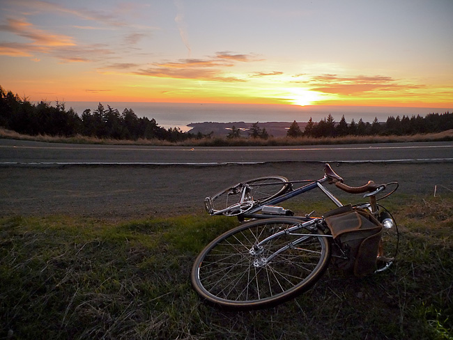
Northern California just had a glorious little heat wave. This last gasp of Indian Summer resulted in hot sunny weather with temperatures in the 70’s, and even 80’s, over the week-end.
And for some reason, I got it into my mind late Sunday afternoon that I had to ride until I could get a view of the Pacific Ocean.
The easiest way to accomplish this goal was a 25 mile round-trip with about 2,600′ of vertical climbing.
Here’s a route map and a one-way elevation profile from the ride:
The spit of land in the above image (just past the line of trees) comprises the town of Bolinas and the Pt. Reyes pennisula.
More pictures and a short ride report to follow.
Route Map……US Hwy 1: Heading South from Olema
One really appreciates elevation gains/losses when on a bicycle. To wit, I’ve traveled this stretch by automobile dozens of times and on all those occasions I perceived the route as being perfectly flat.
Anyhow, this stretch of Highway 1 connects the small west Marin towns of Olema and Bolinas. You travel over rolling hills and past park land and old ranches while following the San Andreas earthquake fault along the valley floor. (I wrote a little about this natural history and geology in an earlier post).
Route Map……Fairfax to Angel Island by Land & by Sea
gpsbabel_output[maptype=G_Physical_Map; zoom=11]
Here’s a gps file of the ride to Angel Island. The mileage on the elevation profile is one-way. And the point where the pink line ends on the upper map is where my gps data logger ran out of batteries. It wasn’t a bad place for this to happen, however, as by that time the route was already nearly fully logged and delineated.
Remember you can change map types or zoom in or out to taste, using the Google map control buttons.
Route Map……Port Costa Loop
Route Map……Azalea Hill pass (El. 1,080′)
The short, steep climb followed by the exhilarating descent always clears my head.
On the Road……San Rafael Ridge Loop
The purple line marks paved roads. The green line marks the fire road connecting Ridgewood Rd. in San Rafael to Fawn Dr. in San Anselmo.
On the Road……To Lake Lagunitas
Route Map……Cataract to Laurel Dell
If you’re cycling up to Mt. Tam or over the ridge and you want to get off, stretch your legs, and hike, this is a nice side trip. The trail follows a steep canyon with waterfalls, all the way up to Laurel Dell and beyond (potentially to the summit of Mt. Tam).
Route Map……Fairfax-to-Mill Valley via Panoramic Hwy
Route Map……Fairfax-to-San Rafael (Farmer’s Market)
A visit to the Civic Center farmer’s market in San Rafael (open every Thursday and Sunday year-round) makes for an enjoyable little 13 mile loop ride starting from Fairfax. Bring a bike with a large front basket for all your market goodies.
Riding to San Rafael (via San Anselmo) is straightforward. But upon entering San Rafael you must pick your way through downtown to Lincoln Ave. without the benefit of a dedicated bike lane. I usually cruise down 4th St. to Lincoln, which leads to a path that goes under Highway 101 and provides access to the Frank Lloyd Wright designed Civic Center.
The fun part of this ride is making it into a loop — something impossible in a car because there’s no road connecting the Terra Linda neighborhood of San Rafael with San Anselmo/Fairfax. But a narrow paved trail (at the end of Freitas Parkway) connects to the Sleepy Hollow neighborhood making this loop possible, provided you’re traveling by foot or bike.
This short-cut which starts around the 10-mile point is very steep (as you can see in the elevation profile), but relatively short (and I’m often tempted to walk the bike.)

