Archive for the ‘Guerciotti’ tag
Gear Gallery……Having it all? Versatillity, speed, and sprightliness
Is it sacrilege (or fickleness) to doubt my relationship toward my two primary bicycles: the Guerciotti and the Ebisu because each has something the other lacks?
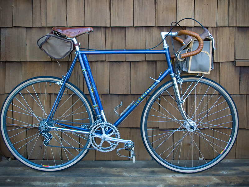
I made some tweaks to my Guerciotti’s set-up about seven years ago and ever since I’ve been pretending it’s a randonneuring-style bike and the truth is it’s really not. The Guerciotti is a racing bike with classic Italian geometry. It doesn’t hold a front handlebar bag that well and although I’ve shoe-horned 28-29mm wide Grand Bois tires onto it, the bike’s narrow clearances will not except fenders.
The bottom line: it’s fast and really fun to ride, although a bit twitchy like an Alfa Romeo.
But most importantly the bike’s super light tubing allows it to “plane” — an elusive (some say phantom) sensation whereby the frame’s flexibility works in a sort of mysterious, mechanical harmony with the rider. Jan Heine, the publisher of Bicycle Quarterly, coined the term “planing” as it pertains to bicycle performance and has written about these subjects extensively.

Guerciotti (circa 1982-83, 59cm frame)
My Ebisu, on the other hand, was purposely built to carry a loaded handlebar bag (it can even be set up with front panniers for a short tour) along with wide tires (up to 38mm wide) and fenders. But if I’m honest, the Ebisu is not quite as responsive and fun as my Italian racing bike. Continuing the car analogy, if the Guerciotti is an Alfa, the Ebisu is a Subaru Forrester.
So what are the underlying causes of these differences? I’ve pinpointed two:
- Responsive shifts: the 9-speed cassette on the Ebisu makes manual friction shifting a fine, delicate operation. On the other hand, the Guerciotti drivetrain is based around a more direct, positive feeling, 6-speed freewheel. The difference is significant.
- Planing: my Ebisu frame feels stiffer than the Guerciottti and it does not noticeably plane while riding. Understandably so. The Ebisu was constructed by master builder Hiroshi Iimura as more of an all-around bike capable of mid-to-light weight touring. But I do miss the feeling of riding my racing bike when I ride something else. The joy of pedaling hard and covering varied terrain is related — at least for me — to the stiffness of a bicycle’s frame.
It took time, but I discovered my preference for a more flexible frame through trial and error after pedaling different kinds of frames many miles over northern California’s hilly roads (and from reading Jan Heine’s articles in Bicycle Quarterly).
My Ebisu is perfectly designed for its purpose and performs more the way I like when it’s carrying extra weight. It seems that the additional weight (since I’m only 150-55 lbs.) causes the Ebisu frame to flex more than normal thus making the frame more responsive and lively when fully-loaded (as opposed to when it is ridden un-loaded).

Ebisu (circa 2006, 59cm)
Where does this leave me?
It means I need to find a bike close in design to the Ebisu, but with light, flexible, tubing like the Guerciotti. The only question is whether to base it around a 700cc 32mm tire or the highly-reviewed 650B 42mm Hetre tire?
Below are some images of bikes and makers which include the option of using super lightweight tubing in their designs.
 Jan Heine’s custom Rene Herse
  MAP bicycle in 700cc wheel size
 Boxer Bicycles
  MAP bicycle in 650B wheel size
 Box Dog’s Pelican (a local Bay Area company).
 Terraferma Cycles (courtesy chasingmailboxes)
On the Road……Near GGNRA’s Coastal Trail: Marin Headlands

 Show on map
Riding east on Bunker Rd. I found this picaresque spot, made even more so by the recent rain which created a mini-wetland.
It’s directly off the main road, but also at the end of a fork that connects to the Coastal Trail (used for hiking and mountain biking), which leads up the ridge to the traffic circle on Conzelman Rd. or (if followed in the other direction) down to the beach at Rodeo Cove.
The Coastal Trail eventually reaches Fort Cronkite, which houses an eclectic group of organizations including the Headlands Center for the Arts, Foundation for Deep Ecology, and The Marine Mammal Center.
On the Road……Above Bonita Cove: Views of the Bridge and Sutro Tower

I’m not exactly sure what this graffiti artist is trying to communicate. Perhaps, it’s that war = destruction? (since the opposite of creation is destruction).
But speaking of language, the December 24th issue of The New Yorker magazine had a curious article by Joshua Foer about an amateur linguist named John Quijada. When he wasn’t working at the Department of Motor Vehicles, Quijada spent his spare time (extending over 25 years) engineering a new language and grammar system combining what he believed were the best aspects of all the world’s languages.
Here’s a quote from the beginning of the article:
In his preface, Quijada wrote that his “greater goal” was “to attempt the creation of what human beings, left to their own devices, would never create naturally, but rather only by conscious intellectual effort: an idealized language whose aim is the highest possible degree of logic, efficiency, detail, and accuracy in cognitive expression via spoken human language, while minimizing the ambiguity, vagueness, illogic, redundancy, polysemy (multiple meanings) and overall arbitrariness that is seemingly ubiquitous in natural human language.”
Ithkuil has two seemingly incompatible ambitions: to be maximally precise but also maximally concise, capable of capturing nearly every thought that a human being could have while doing so in as few sounds as possible. Ideas that could be expressed only as a clunky circumlocution in English can be collapsed into a single word in Ithkuil. A sentence like “On the contrary, I think it may turn out that this rugged mountain range trails off at some point” becomes simply “Tram-m?öi hhâsma?p?uktôx.”
This is really quite odd.
Ithkuil seems to be a language devoid of nuance, implication, metaphor, and for that matter: poetry!
On the Road……Marin Headlands Gun Battery on MLK Holiday

The coastal fortifications (as seen in the image above) from a time when nation-states confronted each other with crude, 20th century explosives and projectiles are hard to miss as you bicycle through the Marin Headlands.
These gun batteries are now quiet, but our world still does not embrace Martin Luther King’s practice of non-violent resistance or Mahatma Gandhi’s ethos of satyagraha.
King was influenced by Gandhi, who, according to the author Thomas Weber (Gandhi as Disciple and Mentor, Cambridge University Press, 2004), would quote the poet Shelley at his mass rallies in India.
So in honor of Martin Luther King Day, here are a few stanzas from the English Romantic poet, Percy Bysshe Shelley.
Stand ye calm and resolute, Like a forest close and mute, With folded arms and looks which are Weapons of unvanquished war. And if then the tyrants dare, Let them ride among you there, Slash, and stab, and maim and hew, What they like, that let them do. With folded arms and steady eyes, And little fear, and less surprise Look upon them as they slay Till their rage has died away Then they will return with shame To the place from which they came, And the blood thus shed will speak In hot blushes on their cheek. Rise like Lions after slumber In unvanquishable number, Shake your chains to earth like dew Which in sleep had fallen on you- Ye are many — they are few
–Percy Bysshe Shelley (from The Masque of Anarchy)
On the Road……Galilee Harbor, Sausalito

On the Road……Back in SF Bay, Marin Headlands

I’ve been transferred back to San Francisco!
Although Tucson is a charming place and there’s a lot I miss about the Old Pueblo — it’s really amazing to feel the ocean air again.
This is the view (at approximately 7 PM) after riding about 3 miles up the hill from my new place in Sausalito, CA.
On the Road……Mt. Lemmon
 No complaints about my trusty steed. She carried me perfectly up and down this ride (60 miles in total). One water bottle in the downtube cage and one in the front handlebar bag.
On the Road……Saguaro National Park Loop, Tucson

Saguaro National Park is part of the national park system so bicyclists are required to pay an entry fee just like everyone else. The cost is $5 (with re-entry permitted for seven days with the receipt). Automobiles are charged $10.
As Laura commented in the previous post, a National Park Service annual pass can be purchased for $80, allowing unlimited entry to all parks and national monuments for 12 months.

On the Road……Contemplative bicycling along the Santa Cruz River

 Bicycling in Tucson has been an adjustment for me.
The biggest difference is that it takes about 60 minutes of riding to get out of town and into a more natural environment. Those 60 minutes can feel even longer as this time is usually spent traveling on very busy, automobile-dominated roadways, which I find rather stressful.
Don’t get me wrong, There are plenty of bike lanes and routes criss-crossing Tucson, but most of these routes (as mentioned above) do not inspire my style of carefree and joyous riding. It may be a surprise to some, but I’m not an ideological cyclist. I don’t fight against conditions be it weather, road surface, or personal safety just to prove that bicycling is a viable form of transit (although I respect those who do). I ride a bicycle simply because of its potential to enhance the quality of my everyday life.
In other words: I ride a bicycle out of an Epicurean desire for happiness.
Now there are always exceptions. Sometimes I ride for physical exercise. Sometimes I ride to accomplish a goal (e.g. to reach the top of the mountain, or to get from point A to point B within X amount of time). But for the most part bicycling is a way to enhance my own pleasure by drawing me closer to my surroundings and helping me feel the aliveness of my own body.
 The bike paths along the Santa Cruz and Rialto Rivers are some of the exceptions — places in Tucson where carefree, contemplative riding is easy.
On the Road……9-11, 10th anniversay, Nogales Highway, Tucson


On the Road……A rattlesnake encounter in Sabino Canyon

This is the end of Sabino Canyon’s paved road. Mosquito’s are biting my forearms and shoulders. Twilight is descending (note: for a twilight ride overlooking the Pacific Ocean see this post).
As I’m heading home, about halfway down the mountain, the light is 85 percent gone. Coasting slightly downhill at about 10-15 mph, I suddenly notice a shape in front of my wheel. Without thinking, I swerve. Actually, there wasn’t enough time to swerve; rather it was just a quick flick of the wrist and handlebars — first right, then left.
I immediately look back over my left shoulder and see a snake falling to the ground, as if recoiling from a near vertical strike.
The part of my brain that processes information informs me that the sensation I felt against my leg a fraction of a second ago was the rattlesnake defending itself against what it perceived as a large, warm-blooded creature (that is, me) bearing down on it.

I stopped my bicycle; went back up the road 20 feet; directed my headlight to illuminate the scene; and snapped this picture!
The encounter reminded me of one of my favorite pieces of writing — Snaketime — an essay originally published in the WildEarth Journal by Charles Bowden (re-printed in this book, which as of August 2011 had copies available for $.01).
Here’s an excerpt where Bowden suggests how a snake perceives the world:
For the snake a few things are obvious: I am large, and this is certain because of my footfall. She can hear the footfall of a mouse. I am rich in odor. She can pick up the faintest scents, identify them, and follow a single strand as clearly as if it were signage on an interstate highway system…And I am irrelevant unless I get too close. She will ignore me if I stay six feet away. She will ignore me if I become motionless for 180 seconds.
If I violate the rules of her culture, she will work through a sequence of four tactics. First, she will pretend to be invisible and hope I do not see her. If that fails, she will try to flee. If that fails, she will rattle in hope of frightening me away. And finally, if I am completely ignorant of simple courtesy and get within a foot or so of her, she will attack me…
She herself is cultured. In her lifetime, she will attack maybe twenty or thirty or forty times. She will never attack any member of her own species. She will never be cruel. She is incapable of evil.
–Charles Bowden, from the essay Snaketime
Nathan
Ride Report……Toward the Summit of Mt. Lemmon, Part 1

My Mt. Lemmon ride was rather ill-planned, meant only as an exploratory trip to see what this mountain is all about.
It began on a Sunday afternoon, fueled by a morning capuchino and cinnamon roll from Cartel Coffee Lab (which was excellent and made me wish I had snapped a picture for an espresso review — click here for the review archives…but I digress).
Getting off to a late start (about 12:30 with the sun already directly above), I parked at the Safeway on Tanque Verde and Catalina Highway, 2-3 miles away from where the road begins to steepen. I wore wool shorts, some puma shot-putting shoes, a cotton tank-top with a lightweight, long-sleeve polyester shirt over that, a scarf-like buff around my neck, and zinc oxide sun protection on my face. I put a vietnamese-style baguette sandwich in my handlebar bag and a full water bottle in my downtube cage.
I felt great the first 7 miles as I climbed the initial few thousand feet. With each switchback the valley began fading away. I remarked to myself that this was the most comfortable I’ve felt on a bike since coming to Tucson: few cars, scenic views, and to me, the satisfying rhythm of a long, hard hill climb (which is what I was used to in California).
Just after making the above picture of this prickly pear cactus, the sound of rapid gunshots rang out from a pickup truck directly across the road. I quickly ascertained the pistoleros were not aiming their bullets at me, but I still felt vulnerable. I didn’t linger.
As I covered this initial ground, I guzzled water at a rate that naively assumed I could fill-up at the numerous official campgrounds en-route (e.g. at mile 6, 12, 18 etc.). So I rolled into the Molino Basin Campground — at around 1:30pm and well into the heat of the day — with a nearly empty water bottle. It was only then that I learned there would be no more water until the Palisades ranger station (more than 14 miles ahead and 4,000 feet above me).
I gamely rode another mile or so, but began to tire. The hot and extremely windy conditions made for tough riding. At times, it felt as though I was barely moving at all as I hammered my lowest gear into 30-mph gusting headwinds.
The opportunity to take a rest and eat something arrived in the form of the Gordon Hirabayashi recreation site. My energy was mostly spent and I was out of H2O. I ate half a sandwich and thought that this would be the end of my climb….
…TO BE CONTINUED in PART II
 Tired, thirsty, and hunkered down in a small patch of shade.

On the Road……Toward the Summit of Mt. Lemmon

This past Sunday I decided to head toward the top of Mt. Lemmon to see how far I could get. It’s a tough 20+ mile ride going from the desert floor (at around 2,000′ of elevation) all the way up to a subalpine forest (around 9,000′).
I hope to have a detailed report and more pictures soon. Suffice it to say: I only made it about half way (around 6,000′ just below Windy Point).
Q: do you notice anything wrong with the picture above?
A: the single water bottle (and lack of water along the route), which proved to be my critical undoing!
Gear Gallery……Velo-Geo-Photo blogging tips, Part I

Since I began publishing this blog a year-and-a-half ago, I haven’t talked much about behind-the-scenes stuff.
So I’m changing things up today.
In this post (Part I), I’m outlining some of the tools and equipment I find most useful as a Velo-Geo-Photo-blogger. Then, in the next installment (Part II), I plan to talk about my general process for making photographs and observing my surroundings while out on a ride.
First, the tools of the trade:
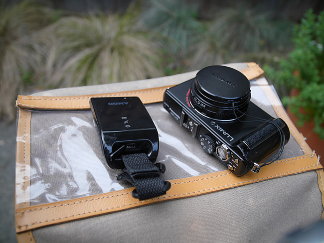
A camera: When riding, I almost always bring along a Panasonic LX3 with its Leica branded 24-60mm lens. I’m a big fan of Panasonic/Lumix cameras. I had the LX1 before this and also own the less known L1. At 60mm, the LX3 is a bit lacking on the long-end of its zoom range (I think the updated LX5 zooms to around 90mm), but it is very compact and fits perfectly in the pocket of my handlebar bag.
A gps logger: My AMOD 3080 is critical for determining the GPS coordinates of a photo or location. I can record individual points of interest by pressing a button during the ride. After the ride, I can also time sync the gpx file of the data logger with the photo files in order to determine the precise location of each photo. (Note: a more elegant and time saving solution would be to carry a camera with built-in GPS capabilities which writes geo-data automatically to the photo’s metadata. Then I would only need one gadget on board, not two.)
Some critical equipment
A front rack and handlebar bag: My old Guerciotti has neither cantilever brake mounts on the forks nor eyelets on the front dropouts so my rack choices are limited. I ended up installing the versatile Mark’s Rack from Rivendell and use a classic TA bag I bought on eBay many years ago. I don’t have a decaleur so the bag flops around a bit when I ride. Some plastic stiffeners would help I just haven’t gotten around to addressing this problem yet.

Camera, GPS logger, and TA bag
Photo processing software: I use Adobe Photoshop CS3 and Bridge (which acts as a digital light table for viewing and sorting images) on an older Mac G5 and Apple cinema display.
For making images and posting them to the web I usually follow these steps:
- First, create a composition to best capture the subject matter (this can take several attempts and may require careful cropping of the image).
- Make creative changes as needed (e.g., adjustments to contrast, color, or luminosity) so the image expresses the feeling of the scene as it was experienced. This is critical. Remember what Ansel Adams said: “The negative [read: digital raw image] is the score; the print is the performance”.
- Re-size the image (in my case to around 650 pixels wide) and down sample the resolution (to around 100 ppi) so it properly fits the intended space and so the file doesn’t take up too much memory.
- Lastly, sharpen the photo while viewing it at the final size and resolution. This is very important and a reason many images do not look very good is that they are not optimized for viewing on the web at the actual size they are displayed.
A blogging platform: I use WordPress.org and a heavily modified version of the Black Letterhead theme. I also use various WordPress plug-ins. The most indispensable is Geo Mashup. It’s fantastic. One of its most useful features is the ability to display each post’s image on a main map page. I also use XML Google Maps, WP-prettyPhoto, and WordPress Video Plug-in.
A bicycle: Often it’s a steel-framed Guerciotti that I’ve owned since high school outfitted with mostly Campy components, a recently added 12-28 suntour 6-speed freewheel, a Brooks titanium rail saddle, and Grand Bois 28mm tires!
On the Road……Guerciotti on the Golden Gate Bridge

I recently did some exploring around the Golden Gate Bridge (and down by The Warming Hut).
This view is from the western side of the bridge looking toward the south-west. I believe the Seacliff/Richmond neighborhood is visible in the background.
Ride Report……Port Costa Loop, Part II

Long overdue, this is Part II of my ride report.
(Here is Part I and here again is the map of the route).
The broad outlines of this ride came to me as I looked at the location of my friends’ house on a map. This would be a circumnavigation, via two major urban bridges, of the Carquinez strait — a watery narrows that California’s two mighty rivers, the Sacramento and San Joaquin, must pass through before emptying into the San Pablo and San Francisco Bays.
Port Costa — surrounded by rolling green hills — was the perfect launching point for such a ride.
Miles 0-10: From Port Costa to Martinez bicyclists can use the old highway, which is closed to car traffic. I passed the occasional hiker and was treated to rolling hills, scenic views of the water and the old rail road tracks, and a final, satisfying descent into the town of Martinez. I breezed in feeling energized and thus decided to go looking for the John Muir historic monument rather than sticking to the course I had initially set. (Read about that side trip here).
Miles 11-20: The second third of the trip took me from downtown Martinez across the Benicia Bridge to Southampton Bay and the Benicia state recreation area. This was easy, pleasant riding never too far from the shoreline. I rode past past marinas filled with expensive yachts and late Sunday afternoon picnic goers. I stopped frequently to make photographs and found my way using a variety of bike paths and shared roads. I was never entirely sure if I was on my planned route, but I wasn’t too concerned as “Bike Route” signs were plentiful and all roads seemed to propel me toward the state park.
Miles 21-30: During the last third of the trip, after leaving Benicia state park, the route finding and bicycle riding became more difficult. The bike lane ended and I had to navigate a number of challenges:
- first was a curving, shoulder-less off-ramp leading up to Columbus Parkway and a narrow two-way bridge near the intersection with I-780.
- route finding became more difficult since I screwed up my Google bicycling directions by accidentally printing a mirror image of the route (starting at point B going to A, rather than A to B). As a result, I had to read the directions backwards (from the bottom of the page up) and calculate whether left and right turns were also reversed. It was a mess.
- a critical street sign was missing and as I pedaled up what seemed the biggest incline of the trip I was unsure if was even on the correct road (later I confirmed I was on Benicia Rd.).
- in order to find the approach to the bike/ped path of the Carquinez Bridge I had to cross three major interstates (I-780 2 times and I-80 once) and pedal through a few gritty urban neighborhoods (riding in normal street clothes, rather then a skintight lycra outfit, never felt more right).
- since I began my journey after 4:30pm the onset of darkness was a real issue (I don’t have a lighting system on this bike).

So, I pedaled hard the last 6-7 miles, crossed the Carquinez Bridge as the sun dropped below the horizon, and managed to arrive back in Port Costa just after 8pm.
My friends had taken a twilight stroll and were not yet home. I was a little tired and rather hungry (since I didn’t eat anything on route), but took solace in the satisfaction of having just circumnavigated the Carquinez Strait.
On the Road……I-780 Overpass

On the Road……Heading toward Azalea Hill Pass

On the Road……Meadow Club, Fairfax

I live in a region with a drought prone mediterranean climate and so expressing one’s feelings about the rain (its frequency and abundance) is a local past-time and, I think, a reflection of becoming a true inhabitant of this dynamic ecological assemblage.
I love the rain — especially late season March/April rains, but it also reduces my riding (above is a fair weather picture from a mid-month ride).
And despite many rumors to the contrary, rainfall this year is just “average”. But “average” = “great” because now our reservoirs are finally full.
Stats from MMWD’s website:
Average year-to-date rainfall (inches): 46.3
Actual year-to-date rainfall (inches): 45.1
Current, reservoir storage (% of capacity): 99
Same time last year, reservoir storage (% of capacity): 84
Now we need to hope plans to restore native Coho salmon populations will soon start paying off.
On the Road……Happy New Year!
The Friday Cyclotouriste wishes everyone a happy New Year’s Day, 2010. As you spread the joy and benefits of riding bicycles this year may you suffer few flats, encounter many interesting people, consume delicious food and drink, and experience only tailwinds during all your rides!

On the Road……NO CAMPING, NO BOATS, NO SWIMMING…
…NO OPEN FIRES, so says MMWD. Still, you can always ride a bicycle or go for a hike via the nearby Cataract Trail. (p.s. thanks to the group from SF who shared water and some delicious grapes at this scenic little spot).

On the Road……Alpine Lake Redux
Just another beautiful northern California October day.

On the Road……Near the Meadow Club
A rare sight: California grasslands with some green, rather than the typical burnt straw. This is the view looking to the northwest across from the Meadow Club on Bolinas Fairfax Road.

click to embiggen
On the Road……Redwood Grove
On one of it’s rare flat stretches, Bofax Rd. winds through a redwood grove. I pulled over because just across the way lay the little fawn.
Gear Gallery……My Trusty Steed
Here’s my early 80’s Guerciotti (59 cm). I bought this as a junior in high school when I was into the idea of bike racing. Top riders in the Tour de France rode bikes like this. It’s still a wonderful bike and I use it for most many of my Friday excursions. It’s been modified from it’s original condition in the following ways: I’ve put wider, more comfortable tires on clincher rims (sew-ups originally), re-tapped the handlebars with hemp-twine and three coats of shellac, added a Brooks saddle, and attached a front rack. She’s relatively light, fast, and can hold extra clothes, food, a camera, or whatever in the old TA bag.

click to embiggen

