Archive for the ‘landscape’ tag
Random Images……Paved Desert Landscape w/ Catalina Mtn’s

I didn’t get much bicycle riding in during 2011 due to distractions (like my job and other photography projects) and the natural fall-off that came along with moving to an auto-centric city with a hot desert climate. I’m not sure what 2012 will produce. A multi-day bicycle tour would sure be fun. Europe would be great.
One thing that is clear: since I began this blog in early 2009, the so-called bicycling movement has gone from a niche activity to a fully mainstream cultural phenomenon. Core77 has an interesting year-end review titled How the Cycling Movement Gained Momentum in 2011.
Anyhow, today’s landscape image was made while riding through the parking lot of the El Con Mall (home to Target, Home Depot, and a 20-screen cineplex). I didn’t have a reason to post this during 2011, but I enjoy the photo so I’m making it my 2012 New Year’s Day image.
I hope everyone has a year full of joyful bicycle riding with family, friends, and loved ones.
Happy New Year!
Nathan
On the Road……Saguaro National Park at dusk

The warm glow of the desert at dusk.
I passed one car and one rattlesnake during the ride. Plus, I got to see the sunset.
Random Images……Desert vistas with the iPhone 4’s camera
Many of the pictures posted over the last few months were created with the iPhone’s built-in camera.
The image quality is inferior to my Lumix LX-3, but the LX-3 was itself a compromise. I used it mainly because it was smaller and more convenient to carry on my bicycle than the alternatives.
Now, size and convenience are winning out again — hence the increased use of the iPhone.


Since these images are primarily intended for the web (and never larger than 650 pixels wide) I have some margin for error in terms of image quality. That’s why I can still produce acceptable results even when facing tricky lighting situations like those seen in these desert vistas. (However, for the first shot I had to combine two exposures in order to retain marginal detail in the foreground shadow areas.)
The biggest drawback is that printing larger images for a gallery show or portfolio may not be achievable. For this, I could really use a larger sensor, but still compact, Olympus EP-3 or Fuji X-100 — which are the cameras I’m drooling over currently.
However, at this point, I should remind myself of the unlimited nature of material desire and the profound teachings of the Buddha — especially his “Second Noble Truth.”
Nathan
On the Road……A rattlesnake encounter in Sabino Canyon

This is the end of Sabino Canyon’s paved road. Mosquito’s are biting my forearms and shoulders. Twilight is descending (note: for a twilight ride overlooking the Pacific Ocean see this post).
As I’m heading home, about halfway down the mountain, the light is 85 percent gone. Coasting slightly downhill at about 10-15 mph, I suddenly notice a shape in front of my wheel. Without thinking, I swerve. Actually, there wasn’t enough time to swerve; rather it was just a quick flick of the wrist and handlebars — first right, then left.
I immediately look back over my left shoulder and see a snake falling to the ground, as if recoiling from a near vertical strike.
The part of my brain that processes information informs me that the sensation I felt against my leg a fraction of a second ago was the rattlesnake defending itself against what it perceived as a large, warm-blooded creature (that is, me) bearing down on it.

I stopped my bicycle; went back up the road 20 feet; directed my headlight to illuminate the scene; and snapped this picture!
The encounter reminded me of one of my favorite pieces of writing — Snaketime — an essay originally published in the WildEarth Journal by Charles Bowden (re-printed in this book, which as of August 2011 had copies available for $.01).
Here’s an excerpt where Bowden suggests how a snake perceives the world:
For the snake a few things are obvious: I am large, and this is certain because of my footfall. She can hear the footfall of a mouse. I am rich in odor. She can pick up the faintest scents, identify them, and follow a single strand as clearly as if it were signage on an interstate highway system…And I am irrelevant unless I get too close. She will ignore me if I stay six feet away. She will ignore me if I become motionless for 180 seconds.
If I violate the rules of her culture, she will work through a sequence of four tactics. First, she will pretend to be invisible and hope I do not see her. If that fails, she will try to flee. If that fails, she will rattle in hope of frightening me away. And finally, if I am completely ignorant of simple courtesy and get within a foot or so of her, she will attack me…
She herself is cultured. In her lifetime, she will attack maybe twenty or thirty or forty times. She will never attack any member of her own species. She will never be cruel. She is incapable of evil.
–Charles Bowden, from the essay Snaketime
Nathan
Route Map……Sabino Canyon Trail with elevation chart

Note to self: starting at my house — rather than the Sabino trail head — would make this an interesting 30 mile ride.
On the Road……The Sabino Canyon trail

This trail leads to all kinds of hiking possibilities in and around the Santa Catalina Mountains and Mt. Lemmon. The road is paved for about 4 miles, then ends, after crossing Sabino Creek 7-8 times along the way.
Nathan

On the Road……A Sabino Canyon ride on the Brompton

More and more I reach for the Brompton when heading out for short rides. I suppose it was just a matter of time before I took the little folder up the Sabino Canyon Trail.
Just a few weeks ago, the Brompton was transporting me around downtown SF and now here we are out in the desert — such a versatile machine!
Nathan
On the Road……The Teddy Bear Chollo of Sabino Canyon

I’m still getting settled here in Tucson, but I’m making an effort to sustain my 11-mile, round trip, bicycle commute to work (at least before the temperatures reach the triple digits).
Tucson’s beautiful Sabino Canyon is open to bicyclists after 5:00pm, which is where this image was made.
The subject seen here is my current favorite cactus: the Opuntia bigelovii or Teddy Bear Cholla.
Nathan
Featured Comment by Laura: “It looks like it was a hard dry winter for that area, so not much of a spring bloom. It’s one of the great joys of the desert to see it in bloom, so if you’re there next year I hope it’s a good one! This site is useful for checking out what’s happening with the fleurs. http://www.desertusa.com/wildflo/wildupdates.html (lots of ads, but the info is good.) I have indeed removed teddy bear cactus spines with pliers. Not from my own calf, I’m happy to say–it weren’t pretty.”
Nathan replies: What a great website. It confirmed the two other blooming plants I’ve been seeing around Tucson. One is the Hedgehog (Echinocereus) and the other is the Ocotillo (Fouquieria splendens), which is my new, new favorite cactus — but it turns out it is not actually a cactus! (P.S. Laura is a talented botanist pursuing her PhD in Ecology and Evolutionary Biology at Brown University. I always appreciate her comments when I attempt to write about the plant kingdom).
On the Road……Atop the Bolinas Ridge at Civil Twilight

This image from my recent ride along the Bolinas Ridge captures the specific time of the evening — civil twilight — when ambient light takes on a lovely bluish hue prized by painters and photographers.
Twilight, broadly speaking, refers to the time between sunset and dusk AND the time between sunrise and dawn (the chart below is a helpful tool for visualizing this).
But twilight (both morning and evening) is divided, more scientifically, into civil, nautical, and astronomical segments based upon the number of degrees the center of the sun is below the horizon (6, 6-to-12, and 12-to-18 degrees respectively).
Evening nautical twilight (nautical dusk) is said to end once sea navigation via the horizon line is no longer possible. Evening astronomical twilight (astronomical dusk) ends once the dimmest celestial objects (e.g. galaxies and nebulae) become properly visible to astronomical observation.
Commentary: in the context of the virtual world of Texting, Tweeting, and Tagging (from which I claim no exception) it feels palpably iconoclastic (if not downright subversive) to patiently witness our solar system’s sun disappearing ever so gently beyond the planet’s watery horizon.

Chart delineating Dusk, Dawn, and Twilight
Featured Comment by Shoeless Joe: “There is a biological connection, too, as the rods and cones in our eyes perceive light differently at twilight. It is called the Purkinje Shift (or Purkinje Effect). Wikipedia has a good article on it. One of the beauties of cycling is that it affords many opportunities to “patiently witness” the world around us in a way that is unique to the sport.”
Route Map……Ridgecrest Boulevard with Pacific Ocean View
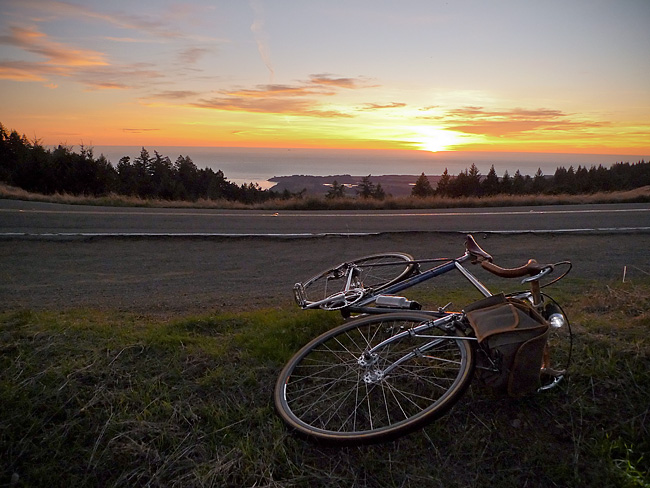
Northern California just had a glorious little heat wave. This last gasp of Indian Summer resulted in hot sunny weather with temperatures in the 70’s, and even 80’s, over the week-end.
And for some reason, I got it into my mind late Sunday afternoon that I had to ride until I could get a view of the Pacific Ocean.
The easiest way to accomplish this goal was a 25 mile round-trip with about 2,600′ of vertical climbing.
Here’s a route map and a one-way elevation profile from the ride:
The spit of land in the above image (just past the line of trees) comprises the town of Bolinas and the Pt. Reyes pennisula.
More pictures and a short ride report to follow.
Random Images……Another View of Mt. Tam from the Marsh

Random Images……Corte Madera Tidal Marsh

Since my previous post highlighted this marsh, I thought I’d share a B&W image made with an old Fuji S2 digital camera. The view is from deep in the marsh looking west toward Mt. Tam across tussocks of Pampas Grass (Cortaderia selloana). Over the course of a couple weeks, I made a series of images in this area last spring. This was one of my favorites.
On the Road……San Francisco Bay’s, Angel Island

I bicycled to Angel Island (via ferry) over the long holiday week-end. It was a typical July day on the San Francisco Bay — patches of brilliant sunshine mixed with belts of fog and massive wind gusts, due to cold ocean air being sucked into warmer inland areas.
The image above was made on the SW side of the island below the summit of Mount Caroline Livermore (El. 788′). Note downtown SF, Alcatraz, and the Golden Gate Bridge in the background. (You can click on the image for an expanded view).
(Wikipedia fact: Angel Island was part of the mainland until about 10,000 years ago, when sea levels rose as the last ice age came to an end.)
More images, a map, a short ride report, and an espresso review to come.
On the Road……Carquinez Strait Loop, near Benicia
Part 1 of my ride report was published awhile back. Stay tuned for Part II and the last of the photos from this scenic loop ride.
* Remember you can always click the  Show on map under the photo to view the location on a map.
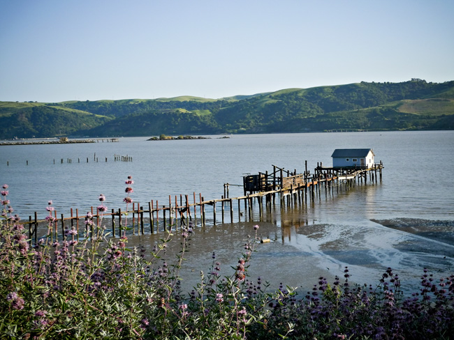
View of the Carquenez Strait looking south from Benicia
The photo caption says it all.
On the Road……Meadow Club, Fairfax

I live in a region with a drought prone mediterranean climate and so expressing one’s feelings about the rain (its frequency and abundance) is a local past-time and, I think, a reflection of becoming a true inhabitant of this dynamic ecological assemblage.
I love the rain — especially late season March/April rains, but it also reduces my riding (above is a fair weather picture from a mid-month ride).
And despite many rumors to the contrary, rainfall this year is just “average”. But “average” = “great” because now our reservoirs are finally full.
Stats from MMWD’s website:
Average year-to-date rainfall (inches): 46.3
Actual year-to-date rainfall (inches): 45.1
Current, reservoir storage (% of capacity): 99
Same time last year, reservoir storage (% of capacity): 84
Now we need to hope plans to restore native Coho salmon populations will soon start paying off.
On the Road……Suburbia

the suburbs
On the Road……Super Bowl Sunday
The view from the the top of the secret (or not-so-secret) bike path connecting San Rafael to San Anselmo that I mentioned here. From the San Rafael side, the path connects with Fawn Drive in San Anselmo.
I’m returning from the farmer’s market and the Ebisu’s rear rack is filled with leeks, carrots, and onions; the front bag with a dozen eggs, a head of cabbage, a turnip, and a shallot.
Oh yeah, congratulations to the Super Bowl champions — the New Orleans Saints!

On the Road……Cataract to Laurel Dell

On the Road……Nicasio Valley Road

This image was buried in my cleaning house 2009 posting. On second viewing, it deserves full-size treatment. A few others from that gallery will probably show up full size as well, if they deserve it.
On the Road……Looking Toward Bolinas

Over the ridge and heading toward the ocean, I’m treated to a glimpse of the Bolinas Lagoon, the Bolinas Mesa, and the Pacific Ocean (visible in that order from near to far).
On the Road……Santa Cruz

This is where your brussel sprouts come from……and the last bit of farmland before entering Santa Cruz (just past Wilder Ranch State Park).
One of my knees was really killing me at this point (and by killing me, I mean it felt like I was being stabbed in the knee with two screw drivers). I later discovered I had stupidly pedaled 100 miles on a saddle that was set too high. Lesson learned.
On the Road……Heading to Santa Cruz, Hwy 1

Looking northwest, past Devil’s Slide along Highway 1.
On the Road……More Panoramas, Ridgecrest to Mt. Tam

Ride Report……Summit of Mt. Tam

The recent post about Paul De Vivie inspired me to do something I’d never done before: bicycle from my house in Fairfax to the summit of Mt. Tamalpais. (Velocio’s seventh bicycling commandment, or one interpretation thereof, is to never ride without a purpose — see Velosophy.)
So today, I gave myself this purpose.
I left about 12:30pm and returned about 5:30pm. A three hour climb to the summit; half-an-hour at the top; and an hour-and-a-half to ride back. The summit is about 2,500′ in elevation, but starting from Fairfax you gain and give up (and gain again) much more elevation over the 35 mile round trip. Roughly 6,000 feet of total climbing is actually involved.
I carried two water bottles, two peanut butter and jelly sandwiches, and a few ounces of cheese and salami, which provided for three food stops.
The weather was partly sunny with an occasional breeze, some light rain, and pockets of dense fog. I had wool knickers, a wool tee-shirt, a long-sleeve wool pull-over, a rain jacket, a neckerchief, a baseball cap, and a wool beanie to counter the variable weather.
It’s mid-June but my cycling season is still young and I am not in great cycling shape yet so today — I suffered. I also forgot to re-fill my water bottles at the summit forcing me to conserve less than half a bottle on the return.
At two points — the steepest section right before the summit and the last major climb on the return — I was assisted by, of all things, a strong tailwind giving me just enough of a boost to get me up and over.
I could not help but wonder if this beneficence was the work of Saint Velocio watching over me.
On the Road……Nicasio Reservoir

On the Road……Nicasio Valley Rd.

On the Road……Nicasio Reservoir
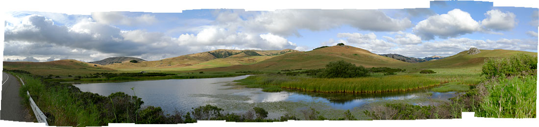
click to enlarge
Today’s thunder showers never materialized so I headed out toward Petaluma this afternoon. The image looking east on Nicasio Valley Rd. near the reservoir is made up of 12 vertically composed images stitched together using the “photomerge” tool in Adobe’s Photoshop CS3. The weather, the clouds, the light: it was jaw-droppingly beautiful!
On the Road……Near the Meadow Club
A rare sight: California grasslands with some green, rather than the typical burnt straw. This is the view looking to the northwest across from the Meadow Club on Bolinas Fairfax Road.

click to embiggen

