Archive for the ‘FAIRFAX-to-MT. TAM’ Category
On the Road……Bolinas-Fairfax Road, near the Lake Lagunitas turn-off

 Show on map
This may not look that steep, but it often feels it (as it’s part of a fairly long climb that eventually crests at the top of the Bolinas ridge).
This rider is almost to the Lake Lagunitas turn.
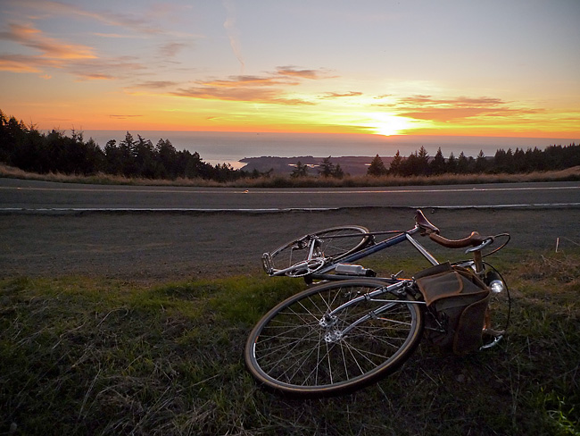
On the Road……Atop the Bolinas Ridge at Civil Twilight

This image from my recent ride along the Bolinas Ridge captures the specific time of the evening — civil twilight — when ambient light takes on a lovely bluish hue prized by painters and photographers.
Twilight, broadly speaking, refers to the time between sunset and dusk AND the time between sunrise and dawn (the chart below is a helpful tool for visualizing this).
But twilight (both morning and evening) is divided, more scientifically, into civil, nautical, and astronomical segments based upon the number of degrees the center of the sun is below the horizon (6, 6-to-12, and 12-to-18 degrees respectively).
Evening nautical twilight (nautical dusk) is said to end once sea navigation via the horizon line is no longer possible. Evening astronomical twilight (astronomical dusk) ends once the dimmest celestial objects (e.g. galaxies and nebulae) become properly visible to astronomical observation.
Commentary: in the context of the virtual world of Texting, Tweeting, and Tagging (from which I claim no exception) it feels palpably iconoclastic (if not downright subversive) to patiently witness our solar system’s sun disappearing ever so gently beyond the planet’s watery horizon.

Chart delineating Dusk, Dawn, and Twilight
Featured Comment by Shoeless Joe: “There is a biological connection, too, as the rods and cones in our eyes perceive light differently at twilight. It is called the Purkinje Shift (or Purkinje Effect). Wikipedia has a good article on it. One of the beauties of cycling is that it affords many opportunities to “patiently witness” the world around us in a way that is unique to the sport.”
Ride Report…A Late Fall Ride and a Pacific Ocean Sunset

I somehow got it into my mind that I needed to see the Pacific Ocean.
The solution was a 25 mile loop — from Fairfax up to and along Bolinas Ridge offering winding roads; steep climbs; fast descents; water and commanding Pacific Ocean views; relatively few cars; redwood forests; oak-studded grasslands; colorful autumn foliage; and, a smattering of wild life (I saw a coyote on top of the ridge and several deer on the way down).
In other words: there’s a bit of everything on this ride.
I departed around 3:30 pm (it’s getting dark by 5:30 pm) so I attached a headlight that I bought for my Brompton folding bike on the Guerciotti. I packed a persimmon and a wool turtleneck in my handlebar bag and wore a wool t-shirt and wool knickers. The weather, however, was unseasonably warm and I was comfortable for most of the ride in just the t-shirt. (Toward the end of the ride, I draped the sweater around my shoulders and tied the sleeves in a loose knot to keep it from slipping.)
I spent most of this ride chasing the sun. I’d catch it, then it would dip behind a ridge. This continued until I got to the final, long climb with the sun well hidden behind the ridge. But as I slowly pedaled up the road — and the 1000′ vertical feet of switch-backs — I realized that at the very top the sun would make a final appearance.
As the image shows, I caught the sun for the final time as I rode atop the ridge.
So what about the bicyclist in the picture?
I passed him about 6 miles earlier, but since I’m always on-and-off my bike making photographs he caught up with me (think of the tortoise and the hare). When I noticed him climbing up the ridge about 100 yards behind me I set-up for this photo.
As the tortoise passed me, I exclaimed, “That’s a beautiful picture!” The tortoise turned briefly toward the sunset and replied, “it’s not real”.
At first I thought he was referring to the almost hyper-real colors (you know how sometimes nature reveals scenes — especially cloud formations and sunsets — that would be unbelievable had you not witnessed them with your own eyes?).
But on further reflection, maybe he was referring to photography itself and the philosophically problematic nature of attempting to reproduce reality with a machine!
Anyhow, I lingered on the ridge for 10-15 minutes and watched the sun dip below the horizon. Mosquitoes bit my arms and legs. I devoured a persimmon then turned on my headlight and rode home.
On the Road……Persimmons: A Most Refreshing Snack

Part of the fun of having a bike equipped with a handlebar bag is how easy it becomes to carry whatever strikes your fancy. I’ll often pack bread, cheese, nuts — sometimes even a small amount of wine!
For this ride out to the ocean, I brought my handlebar bag basics: a few tools, spare tubes, a camera, a cell phone, and a GPS device.
But the extras for this trip consisted of an extremely light merino wool turtleneck (for after sunset) and a persimmon — a sweet, refreshing bit of energy to consume at the turnaround point.
 Wool sweater and persimmon — packed and ready for the ride.
On the Road……Rough Pavement Begets Wide Tires

Roads like this are a big reason why I always recommend wider tires (28mm and above) at lower pressures (50-80psi).
Riding over rough roads on hard, skinny, racing tires (which 95% of bikes seem to have) doesn’t make a lot of sense.
Jan Heine, publisher of Bicycle Quarterly, who I consider an authority on the subject, has done extensive testing of tires at different widths and at different pressures and concluded that wider tires, at lower pressure, can outperform skinny racing tires.
My Guerciotti uses 28mm tires, my Ebisu uses 38mm tires, and I hope to design a future bike around 42mm tires.
(Note: The image was made on the climb through the redwoods up to Ridgecrest Blvd. on way to catch a glimpse of the ocean).
Route Map……Ridgecrest Boulevard with Pacific Ocean View
Northern California just had a glorious little heat wave. This last gasp of Indian Summer resulted in hot sunny weather with temperatures in the 70’s, and even 80’s, over the week-end.
And for some reason, I got it into my mind late Sunday afternoon that I had to ride until I could get a view of the Pacific Ocean.
The easiest way to accomplish this goal was a 25 mile round-trip with about 2,600′ of vertical climbing.
Here’s a route map and a one-way elevation profile from the ride:
The spit of land in the above image (just past the line of trees) comprises the town of Bolinas and the Pt. Reyes pennisula.
More pictures and a short ride report to follow.
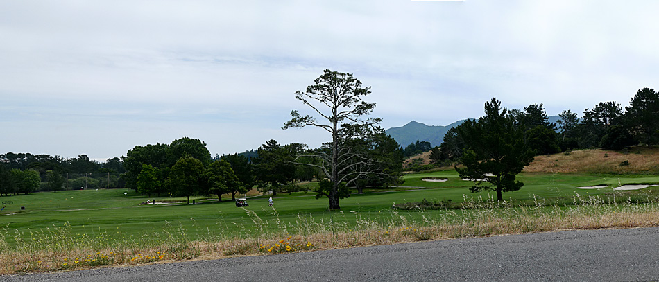
On the Road……Meadow Club, Fairfax

I live in a region with a drought prone mediterranean climate and so expressing one’s feelings about the rain (its frequency and abundance) is a local past-time and, I think, a reflection of becoming a true inhabitant of this dynamic ecological assemblage.
I love the rain — especially late season March/April rains, but it also reduces my riding (above is a fair weather picture from a mid-month ride).
And despite many rumors to the contrary, rainfall this year is just “average”. But “average” = “great” because now our reservoirs are finally full.
Stats from MMWD’s website:
Average year-to-date rainfall (inches): 46.3
Actual year-to-date rainfall (inches): 45.1
Current, reservoir storage (% of capacity): 99
Same time last year, reservoir storage (% of capacity): 84
Now we need to hope plans to restore native Coho salmon populations will soon start paying off.
On the Road……To Lake Lagunitas
Lake Lagunitas
Lagunita (the Spanish word for ‘little lake’) is the oldest and smallest lake in the watershed. It is also the highest in elevation (notice it’s relationship to the summit of Mt. Tam in the background).
Once you ride up here there’s a lovely little path circling the lake (see my route map).
But calling Lagunitas a lake is a bit of a misnomer: Lagunitas is really a man-made reservoir. One of seven reservoirs providing 75% of the county’s water supply.
The future of this supply is threatened, according to MMWD:
Our analyses show that current water supply will be insufficient to meet projected demand. This shortage would become severe in the event of a serious drought…We can get through one or possibly two dry years, but we would not be able to adequately supply our community in a longer drought.
Yikes!
Luckily, someone is paying atention. The intrepid little non-profit, Sustainable Fairfax is once again taking the lead:
Water project staff and volunteers will be approaching every business, school and resident in Fairfax to see “How Far We Can Go” to reduce our water use through technology and behavior. The idea is to focus intensively on one community to increase water conservation to see if that is an effective model resulting in long-term water savings.
(Note: It was too dark when I arrived to get a satisfactory image. The above shot of Lake Lagunitas was made this past summer…yes, fishing with a permit is allowed.)
On the Road……Near Bon Tempe Lake
You wouldn’t know it, but this is a picture of three wild turkeys (if you squint and use a little imagination you might see them). I was on my bicycle and it was dusk so all I got was this colorful blur.
Still, I think the picture kind of works as an abstract.
Riding around at sundown is usually a good time to see wildlife. I saw three deer and six wild turkeys.
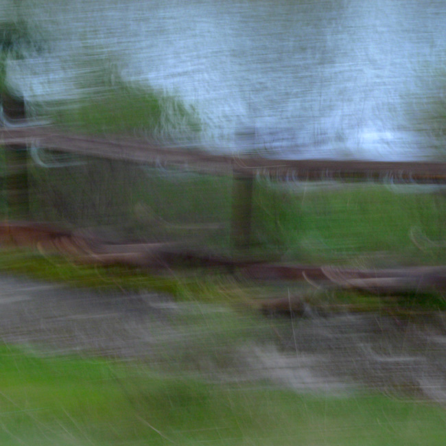
Three Turkeys (Bon Tempe Lake)
On the Road……To Lake Lagunitas – birthplace of mtn. biking

On the Road……To Lake Lagunitas
Last evening the rain let up and I made the quick trip up to Lake Lagunitas. The ride is short, steep, and so very scenic (about 8-10 miles roundtrip with 800′ of elevation gain).
It’s the sort of ride to take when there’s only about an hour of sunlight left in the day. By this time, everything is quieter and water district rangers have shooed away the remaining visitors in automobiles. Only us bicyclists — and the various critters that emerge to forage at this magical time — are left to watch the fading of the light.
While I was off my bike (camera in hand) a small posse of mountain bikers appeared clucking “Hoo Koo E Koo” as they pedaled by.

On the Road……To Lake Lagunitas
On the Road……Cataract Mushroom Gallery
Last week, instead of biking I went for a rainy day hike up the Cataract Trail to Laurel Dell. Lots of mushrooms, but not a Chanterelle to be found 🙁

On the Road…Laurel Dell snack
Persimmon bread and — for a change — some tea!

On the Road……Cataract to Laurel Dell

Let’s pack up and take off and dig Laurel Dell camp. Then we’ll hike over the trails down to the sea and swim.
That’s Japhy Ryder from the Jack Kerouac novel, Dharma Bums. Kerouac based the Japhy character on my personal hero, poet Gary Snyder. Kerouac’s narrator continues below with some local references to areas around Mt. Tam. He takes some poetic license with his description of the landscape and the distinction between Laurel Dell and Portrero Meadows, but still, how cool to have these places I know so well immortalized in a Jack Kerouac novel:
We arrived at Laurel Dell camp at about ten, it was also supplied with stone fireplaces with grates, and picnic table, but the surroundings were infinitely more beautiful than Portrero Meadows. Here were the real meadows: dreamy beauties with soft grass sloping all around, fringed by heavy deep green timber, the whole scene of waving grass and brooks and nothing in sight.
On the Road……Cataract to Laurel Dell

On the Road……Happy New Year!
The Friday Cyclotouriste wishes everyone a happy New Year’s Day, 2010. As you spread the joy and benefits of riding bicycles this year may you suffer few flats, encounter many interesting people, consume delicious food and drink, and experience only tailwinds during all your rides!

On the Road……Fairfax Loop via Mill Valley and Panoramic Hwy

Bay Area on 12/05/09! Got to love the sunshine. And what a picture postcard vista.
You too can find the spot by clicking on the map link under the photo.
In the background are a few of the storied “seven sisters” — a series of beautiful rolling hills. Some are actually quite steep and not so rolling (see also here and here for a few more images of this stretch). I tend to get distracted by the scenery and want to get off my bike and have a little wine, cheese, dried fruit, or whatever else I’ve stowed in my big, roomy front handlebar bag!
On the Road……Fairfax Loop via Mill Valley and Panoramic

A Prius ad was being shot at the top of Bolinas Road and Ridgecrest.
Route Map……Fairfax-to-Mill Valley via Panoramic Hwy
On the Road……NO CAMPING, NO BOATS, NO SWIMMING…
…NO OPEN FIRES, so says MMWD. Still, you can always ride a bicycle or go for a hike via the nearby Cataract Trail. (p.s. thanks to the group from SF who shared water and some delicious grapes at this scenic little spot).

On the Road……Alpine Lake Redux
Just another beautiful northern California October day.

On the Road……More Panoramas Mt. Tam

click to enlarge
I couple weeks ago I posted my first panoramic image. I’m still intrigued by the photomerge feature of Adobe CS3.
On the Road……More Panoramas, Ridgecrest to Mt. Tam

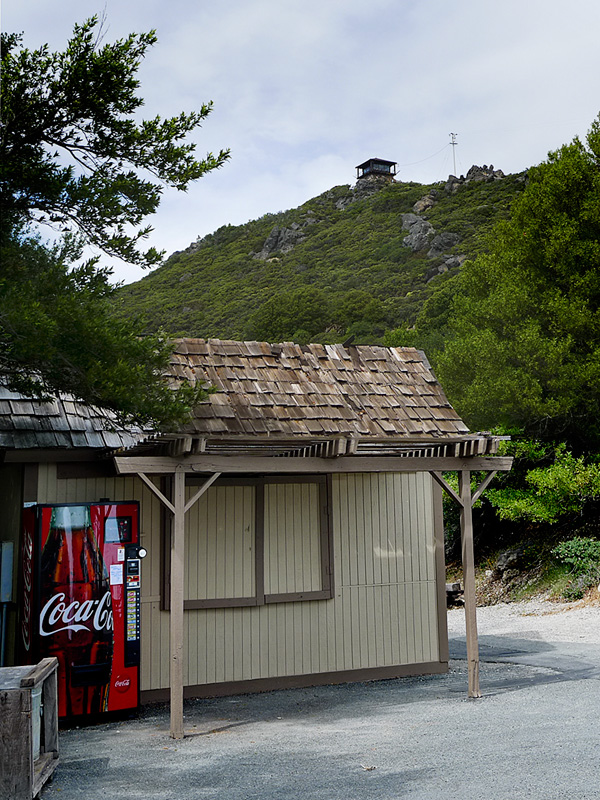
On the Road……View from the Peak

On the Road……View from the Peak

Out of deference to Chief Marin, the defeated Coast Miwok leader, I did not “summit” Mt. Tam (that is, I didn’t walk the final 100 yards up the path to the fire look-out) as legend has it the early Indian inhabitants avoided the peak.
The view is still epic. This is a cropped section from the full image. Notice downtown San Francisco jutting out into the bay (and the fog trailing in from the west) just above the head of the woman in the yellow parka standing on a newly constructed viewing platform.
On the Road……Heading Toward the Summit of Mt. Tamalpais
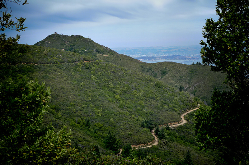
Here are a few views of Tam as one gets progressively closer to the summit.
From the Meadow Club above Fairfax the peak is visible in the far distance (image one). But following this route it goes out of view (with one or two fleeting exceptions) until the last few miles when the summit is once again in view (as seen in images two and three).
On the Road……The Seven Sisters

Riding toward the summit of Mt. Tam, I struggled to maintain momentum over the series of seven undulating hills, known as “The Seven Sisters” (scroll down to the bottom of this page for more details on the sisters).
Apparently, 90% of all North American car commercials are filmed along this stretch of roadway. I’ve only seen filming once twice.
On the Road……Heading Toward the Summit of Mt. Tamalpais

This fellow was just hanging out in the middle of the road. I don’t know how I spotted him (I guess I was just looking in the middle of the road.)
On the Road……Heading Toward the Summit of Mt. Tamalpais

The ever present Sword fern (Polystichum munitum) — one sign that you’re in a redwood ecosystem or on some north facing slope.
On the Road……Heading Toward the Summit of Tamalpais

Lots of variation in terrain on the way to the summit — from oak-studded grasslands and chaparral to the misty Douglas fir and Redwood forests around Alpine Lake seen above.
Route Map……Fairfax-to-Mt. Tamalpais
Ride Report……Summit of Mt. Tam

The recent post about Paul De Vivie inspired me to do something I’d never done before: bicycle from my house in Fairfax to the summit of Mt. Tamalpais. (Velocio’s seventh bicycling commandment, or one interpretation thereof, is to never ride without a purpose — see Velosophy.)
So today, I gave myself this purpose.
I left about 12:30pm and returned about 5:30pm. A three hour climb to the summit; half-an-hour at the top; and an hour-and-a-half to ride back. The summit is about 2,500′ in elevation, but starting from Fairfax you gain and give up (and gain again) much more elevation over the 35 mile round trip. Roughly 6,000 feet of total climbing is actually involved.
I carried two water bottles, two peanut butter and jelly sandwiches, and a few ounces of cheese and salami, which provided for three food stops.
The weather was partly sunny with an occasional breeze, some light rain, and pockets of dense fog. I had wool knickers, a wool tee-shirt, a long-sleeve wool pull-over, a rain jacket, a neckerchief, a baseball cap, and a wool beanie to counter the variable weather.
It’s mid-June but my cycling season is still young and I am not in great cycling shape yet so today — I suffered. I also forgot to re-fill my water bottles at the summit forcing me to conserve less than half a bottle on the return.
At two points — the steepest section right before the summit and the last major climb on the return — I was assisted by, of all things, a strong tailwind giving me just enough of a boost to get me up and over.
I could not help but wonder if this beneficence was the work of Saint Velocio watching over me.

