Biking Culture……Green Bike Lanes in SF!
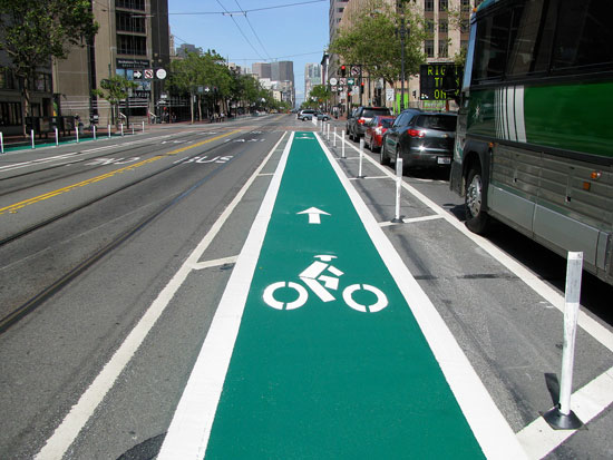
Colored Bike Lane on Market St. Photo: Bryan Goebel.
Over the week-end the city painted all the bike lanes on Market Street (the same street featured in the 1906 historical film posted here a few days ago).
Much better than mere road stencils, these green colored lanes offer a bold and unmistakable visual cue to drivers that bicycles have a place on the street too.
I’m hoping these colored bike lanes are game-changers — a Caesar-crossing-the-Rubicon, no going back moment in the continuing evolution of the bicycle’s acceptance as a mainstream form of transportation.
The full story from Streetsblog can be found here.
Gear Gallery……Mother’s Day Brunch

The Ebisu‘s rear basket is loaded with supplies (grapefruit, rustic cantaloupe, and goat’s milk yogurt) to add to a Mother’s Day brunch held at my brother’s house.

 The basket is made by Wald and it’s attached to the rear rack with plastic zip-ties. I usually anchor the corners and then add a few more ties until it can’t move or slide the slightest bit. For a clean look snip off the zip ties close to the rack. (Here, I was too lazy and left the excess.)
Biking Culture……Bicycles in Vietnam


I was looking at Mai’s Vietnam pictures over at Meli’s blog and became nostalgic. Here’s a few bike-related pictures from a trip I made in 2007.
How I miss Hanoi’s Pho and the Mekong’s delicious Hu Tieu.
Btw, look how practical the bike in the top photo is. Step-through frame. Large front basket. Wide tires. Rear Rack. Built-in kick-stand. Comfortable handlebar position.
Bicycling Culture……Early 20th Century Transit or Horses on Market St.
A hundred years ago, we had an abundance of transit options with high multi-modal connectivity: streetcars and trolleys running continuously (no waiting for a bus to arrive); automobiles; bicycles; ferries plying the bay; railroads; even climate-friendly horse-drawn carriages.
If you have seven minutes to spare watch the whole video; it’s rather amazing and with the soundtrack quite mesmerizing (click on the button with all the arrows to fill the screen).
Among other things, look for the progenitors of today’s fixed-gear riding San Francisco hipsters (at the 1:05 mark) and horses galloping and trotting down Market Street (at the 3:25 and 4:05 marks).
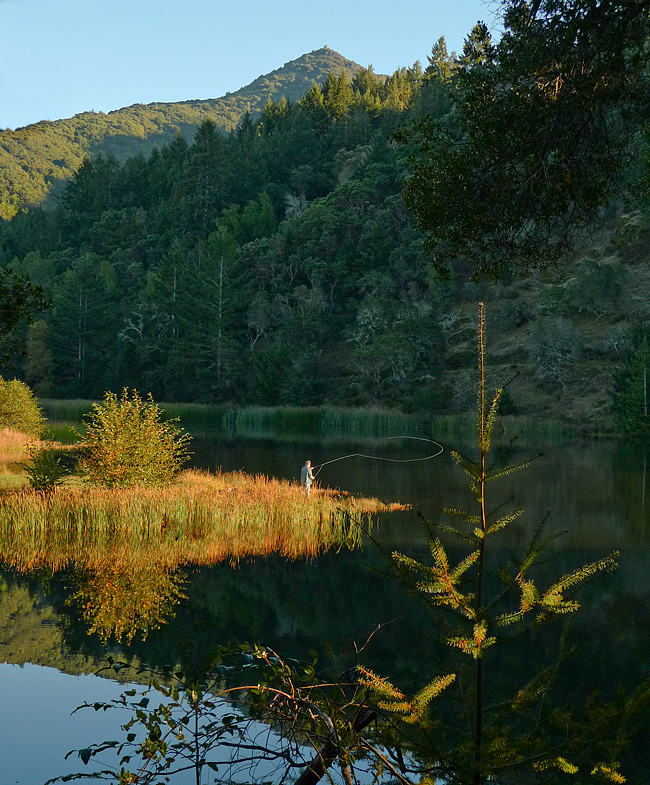
On the Road……Carquinez Strait Loop, near the Benicia Bridge
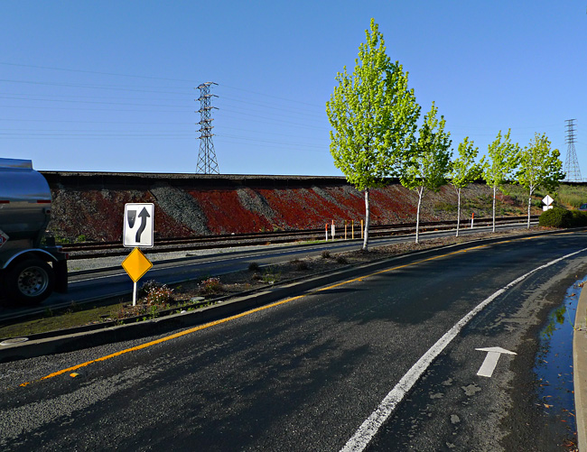
Excellent Class II BIke Lane
 Show on map
Among urban planners:
- Class I is a completely separate bicycle/pedestrian path or roadway (like you see all over Holland).
- Class II is when there’s a separate lane for bicycles (like in this photo).
- Class III is just a shared road, maybe with some road markers here and there.
On the Road……Martinez, and the John Muir House
 You can see from the little squiggle on the Port Costa route map that I made a slight detour from my planned loop.
Here’s what happened:
Noticing the sign “Martinez” as I entered town caused a little voice deep inside my head to say clearly: “Martinez is known for something...?”
It took a few blocks of me pondering, “Martinez, Martinez” and then it struck me — John Muir’s House is in Martinez!
I stopped to ask directions and it was easy enough to find. I went a few miles south on Alhambra Avenue toward Highway 4 and there it was on the right, just past a Vietnamese nail salon and a Subway sandwich shop.
John Muir is one of my all-time heroes. He’s up there with Bodhidharma, Gandhi, Emerson, Thoreau, Gary Snyder, Wendell Berry, Ed Abbey, Aldo Leopold, Cabeza de Vaca, Charlie Chaplin, Walt Whitman, Muhammad Ali, and Velocio.
So I was a little disappointed the historic landmark was closed for the day when I arrived. I just peered in, past the parking lot gate. The place felt a bit sad and ironic, surrounded by its suburban infrastructure.
Even in his day, Muir was not entirely happy in Martinez, so far from the cheerful water ouzel and his beloved High Sierra.
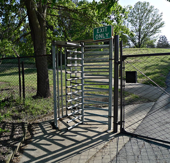
Exit Gate of the John Muir Historic Landmark
On the Road……Port Costa Loop, Old Martinez Highway

Heading east for Martinez on the old highway from Port Costa, I was treated to a rare stretch without any car traffic. This old road is now closed to vehicles and it’s starting to break apart in places — reclaimed by the forces of wild nature!
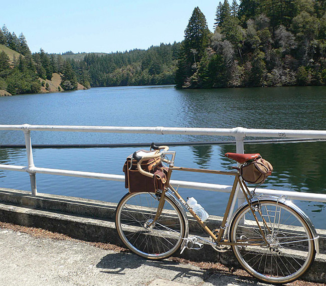
Ride Report……Port Costa Loop, Part I

On Saturday, my friends Forest and Ingrid invited me out to their place in Port Costa — a quirky, Bay Area town (that almost no one has heard of) along the Carquinez strait, surrounded by parks, open space, rolling hills, ravines, pastures, and water views.
I brought my Guerciotti along so I might sneak in a bike ride. I didn’t have a specific route in mind, but the weather was ideal and I anticipated the area would have some great roads.
Ingrid is from Romania and she prepared a delightful tray of appetizers: home-made bread, thinly sliced daikon radish, country cheese, raw milk, strawberries, olives, honey, and sun-dried tomato tapenade. I washed it down with a refreshing Pilsener and then we took a walk down to the old railroad tracks and the shoreline.
Standing near the water, I realized a grand loop around the Carquinez Strait was possible — provided the two bridges accommodated bikes. A neighbor confirmed they do and so I printed out some Google bicycling directions and set out for a ride.
I departed Port Costa around 4:40pm with just a small bottle of water and the food in my belly. I wore my regular clothes: corduroy pants and a lightweight, long sleeve collared shirt over a cotton t-shirt, cotton socks, a baseball cap, Adidas Sambas, and a lightweight hoodie (which I stowed in my handlebar bag should it get cold around sundown).
TO BE CONTINUED…in Part II
Route Map……Port Costa Loop
On the Road……Port Costa Loop Ride

That’s Mount Diablo (El. 3,864′) on the horizon. The slopes and trails of Diablo are where Grant Petersen and the good folks at Rivendell Bicycle Works do their thing.
On the Road……Port Costa Loop Ride

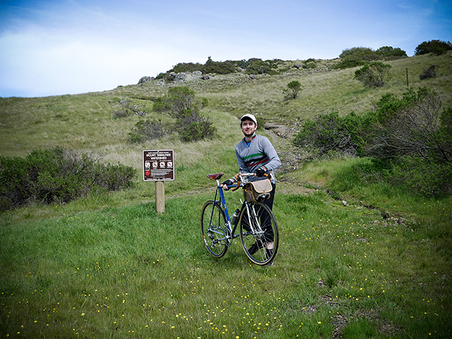
On the Road……Spring time at Azalea Hill Pass
This past Friday I intended to ride to Alpine Lake and back, one of the top 10 short bicycle rides known to humankind IMHO.
But I got distracted by all the wildflowers and only made it to the top of Azalea Hill.
Last time up here I made this photo. I thought I’d share an alternative version highlighting my flashy yellow wind breaker.

And here’s a clumsy attempt to make another 10-second timed exposure at the nearby trail head. (The ground is super saturated and muddy. I had trouble getting set before the shutter released.)
Azalea Hill Trail Head
On the Road……Cumulus Clouds heading toward Azalea Hill

Route Map……Azalea Hill pass (El. 1,080′)
The short, steep climb followed by the exhilarating descent always clears my head.
On the Road……Heading toward Azalea Hill Pass

On the Road……St. Rita’s Church in Fairfax

April 13th. I can’t put off doing my taxes any longer. So I take a quick ride to my local library to pick up some tax forms.
After I get my forms, I’m suddenly struck by the view looking across the street at St. Rita’s Church.
Time to make a quick portrait of the Nishiki Mixte, I think.
For better or for worse, this pretty much sums up the way most of my photos come about: spontaneously and a quite randomly.
Biking Culture……Behold: the Camper Bike
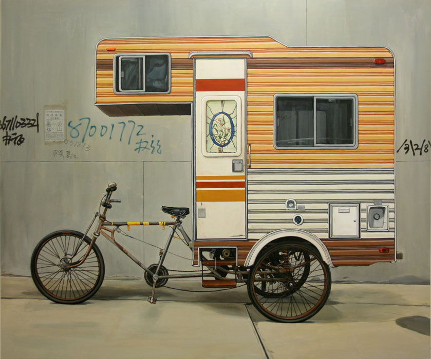
Motherland
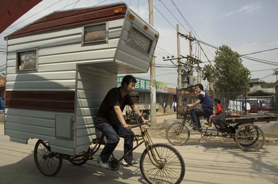
Camper Bike Ride

Scaling Summit
I recently discovered Brooklyn artist Kevin Cyr and his delightful Camper Bike.
From the artist’s website:
Camper Bike, a functioning sculptural piece, built in April 2008. A stand alone piece and the subject of a series of paintings.
Here’s what he said about the Camper Bike‘s origins in an article on a companion piece, Camper Kart.
“I was eating breakfast in a village outside Beijing when I suddenly had this bizarre feeling like I was camping,” remembers Cyr. That feeling, combined with China’s robust cycling culture, was the genesis for the creation of Cyr’s first vehicle, “Camper Bike,” in which he attached a fully functional 3-by-9-foot camper to a three-wheeled Chinese flatbed bike.
Biking Culture……iPads, iPhones, and iBikes?
The iPad is here. What does this mean for bicyclists? Not much, actually. The image below is from a fake news story.

But here’s a real iPhone app called Brakelights, which turns your iPhone into a rear light. Point the screen behind you (strapped to your backpack or saddlebag) and you’re set. The app even knows when you stop moving and the screen then goes from solid to blinking red.

On the Road……Gate 5 Road, Sausalito
Sausalito’s houseboat community — and the dock Otis Redding sat upon while writing, “(Sittin’ On) The Dock of the Bay”

On the Road……Gate 5 Road, Sausalito


On the Road……Sorich Ranch Park, below San Rafael Ridge
March showers bring April flowers…just down the street from the dog park!

Not sure the species, don’t think they’re native.
Cape Daisies, originally from the South Africa, according to my botanist friend, Laura.
On the Road……Meadow Club, Fairfax

I live in a region with a drought prone mediterranean climate and so expressing one’s feelings about the rain (its frequency and abundance) is a local past-time and, I think, a reflection of becoming a true inhabitant of this dynamic ecological assemblage.
I love the rain — especially late season March/April rains, but it also reduces my riding (above is a fair weather picture from a mid-month ride).
And despite many rumors to the contrary, rainfall this year is just “average”. But “average” = “great” because now our reservoirs are finally full.
Stats from MMWD’s website:
Average year-to-date rainfall (inches): 46.3
Actual year-to-date rainfall (inches): 45.1
Current, reservoir storage (% of capacity): 99
Same time last year, reservoir storage (% of capacity): 84
Now we need to hope plans to restore native Coho salmon populations will soon start paying off.
Espresso Review……Java Hut

Even though it’s just a little kiosk in a big parking lot, where else can you sit outside in the sunshine at a big picnic table with the daily paper. Maybe that’s why this place is always filled with bicyclists.
Pro’s: outdoor seating, a convivial local atmosphere, friendly baristas
Con’s: no proper espresso cups
As for the coffee: get a cappuccino or latte.
This is not the place for macchiatos or espressos.
Espresso Review……Java Hut
Friendly neighborhood baristas
On the Road……San Rafael Ridge Loop
It’s Spring…the hills have never been greener!

Great views from the ridge, some extending to downtown San Francisco. Lots of dog walkers and hikers — not many bicyclists up here, though.
On the Road……San Rafael Ridge Loop
The purple line marks paved roads. The green line marks the fire road connecting Ridgewood Rd. in San Rafael to Fawn Dr. in San Anselmo.
On the Road……Near West Portal, San Francisco

Biking Culture……Google Maps, Ferries, and ‘Bicycling’ Directions
In a previous post, I described a new option for getting bicycling directions from Google Maps. Now I’m wondering how this feature deals with odd, highly impractical, or even impossible routes?
Trying to fool Google’s programming elves, I requested directions to a location on the other side of the Bay (i.e., a route from San Rafael to Berkeley).
The challenge, of course, is the bridges; they don’t allow bike travel (except for the Golden Gate Bridge). But Google Maps didn’t blink.
Rather than sending me on an ill-advised circumnavigation of the entire San Francisco Bay, I was instructed, as you can see in the screen shot below, to ride to Larkspur and to put my bike on the Golden Gate Ferry to SF (and then to catch the SF ferry to Oakland) before taking an overland route to Berkeley.
In urban planning circles we call this multi or mixed-mode commuting.
I was surprised Google Maps came up with this solution!

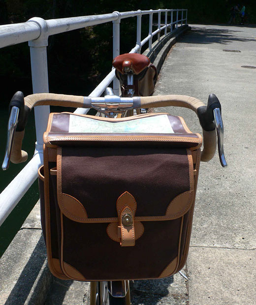
Gear Gallery……Guu-Watanabe Bag (fabrique en Tokyo)
Guu Watanabe Handlebar Bag
I saw a random picture of a handmade Guu-Watanabe bag back in 2006 and thought it was the most elegant design I had ever seen. (I urge you to spend some time exploring the design options now available on their website).
Shortly after seeing one of these bags, I tracked down the maker, Watanabe Shoichi, in Tokyo and together (with limited common language skills) we designed the bag for my Ebisu, emailing measurements and drawings back and forth until we had the proportions just right. I believe I was his first customer outside of Japan.
I’m still delighted with my purchase. It was — and still is — impossible to get a bag this size. It is much bigger than either the Ostrich bag or the Berthoud and it fits the proportions of my 59cm 650B frame just right, as I think is very clear in this photo.
The only flaw — if you can even call it a flaw — are the straps and metal buckles (a slightly fussy or showy detail that has no place in classic randonneuring designs). I would have preferred simple elastic and hook closures (and I notice that Shoichi now uses this type of closure on his current line), but otherwise it is perfect.
Gear Gallery……Guu-Watanabe Handlebar Bag (fabrique en Tokyo)
Guu Watanabe handlebar bag
Gear Gallery……Guu-Watanabe Handlebar Bag (fabrique en Tokyo)
Guu Watanabe bag at Alpine Lake
Gear Gallery……TA Handlebar Bag (fabrique en France)
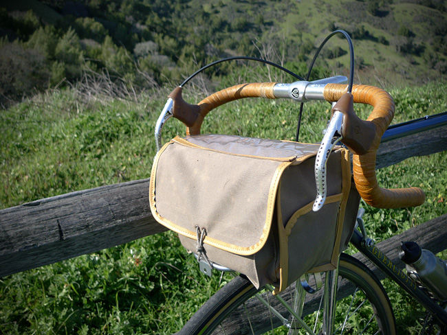
TA Handlebar Bag
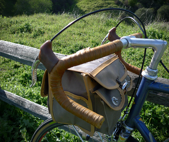
TA Handlebar Bag
The legendary Specialtes TA handlebar bag. Circa 1970s or early 80s. A randonneuring classic.
Kids always stop me on the street and ask who makes it and where can they find one.
Unfortunately, they can’t be found. But modern Acorn bags — while expensive — appear to be just as good (probably better).
Biking Culture……Google Maps and Bicycling Directions!

Google Map example

Bicycling directions user interface
Google Maps today added the option to get Bicycling directions (in addition to Walking, By car, and By public transit). This comes after more than 51,000 cyclists signed an on-line petition urging them to do so.
Google explains how the new feature works here.
For some reason these maps cannot be embedded yet in web pages, but above are some screen shots I made of the new interface and the map generated when I made San Francisco the destination.
Google engineers employ some fancy algorithms to deal with the problem of steep slopes and hills:
Our biking directions are based on a physical model of the amount of power your body has to exert given the slope of the road you’re biking on. Assuming typical values for mass and for wind resistance, we compute the effort you’ll require and the speed you’ll achieve while going uphill. We take this speed into account when determining the time estimate for your journey, and we also try hard to avoid routes that will require an unreasonable degree of exertion. Sometimes the model will determine that it’s far more efficient to make you ride several extra blocks than to have to deal with a massive hill.
Does it work as advertised?
- For the route to San Francisco it missed some smaller bike paths (e.g. the one behind the College of Marin along the canal). Overall, it seemed to make good, safe choices and no blatantly dumb ones.
- However, for a shorter trip to San Rafael, Google had me riding down the Miracle Mile rather than on Greenfield Avenue, which is really, really dumb.
At the very least, this beta version is a useful starting point for getting bicycling directions (and it will certainly become more reliable over time as users report problems).
On the Road……To Lake Lagunitas
Lake Lagunitas
Lagunita (the Spanish word for ‘little lake’) is the oldest and smallest lake in the watershed. It is also the highest in elevation (notice it’s relationship to the summit of Mt. Tam in the background).
Once you ride up here there’s a lovely little path circling the lake (see my route map).
But calling Lagunitas a lake is a bit of a misnomer: Lagunitas is really a man-made reservoir. One of seven reservoirs providing 75% of the county’s water supply.
The future of this supply is threatened, according to MMWD:
Our analyses show that current water supply will be insufficient to meet projected demand. This shortage would become severe in the event of a serious drought…We can get through one or possibly two dry years, but we would not be able to adequately supply our community in a longer drought.
Yikes!
Luckily, someone is paying atention. The intrepid little non-profit, Sustainable Fairfax is once again taking the lead:
Water project staff and volunteers will be approaching every business, school and resident in Fairfax to see “How Far We Can Go” to reduce our water use through technology and behavior. The idea is to focus intensively on one community to increase water conservation to see if that is an effective model resulting in long-term water savings.
(Note: It was too dark when I arrived to get a satisfactory image. The above shot of Lake Lagunitas was made this past summer…yes, fishing with a permit is allowed.)
On the Road……Near Bon Tempe Lake
You wouldn’t know it, but this is a picture of three wild turkeys (if you squint and use a little imagination you might see them). I was on my bicycle and it was dusk so all I got was this colorful blur.
Still, I think the picture kind of works as an abstract.
Riding around at sundown is usually a good time to see wildlife. I saw three deer and six wild turkeys.
Three Turkeys (Bon Tempe Lake)
On the Road……To Lake Lagunitas – birthplace of mtn. biking

On the Road……To Lake Lagunitas
Last evening the rain let up and I made the quick trip up to Lake Lagunitas. The ride is short, steep, and so very scenic (about 8-10 miles roundtrip with 800′ of elevation gain).
It’s the sort of ride to take when there’s only about an hour of sunlight left in the day. By this time, everything is quieter and water district rangers have shooed away the remaining visitors in automobiles. Only us bicyclists — and the various critters that emerge to forage at this magical time — are left to watch the fading of the light.
While I was off my bike (camera in hand) a small posse of mountain bikers appeared clucking “Hoo Koo E Koo” as they pedaled by.

On the Road……To Lake Lagunitas
On the Road……Azalea Hill (EL 1,217′)

Atop Azalea Hill
There’s a lot of cloud cover, but the East Bay is just visible on the far horizon. Mt. Tamalpais is the third peak from the right with Bon Tempe Lake right below.
(I combined five images to capture the whole panorama. Here’s my favorite example of this technique: Nicasio reservoir.)
On the Road……Azalea Hill pass (EL 1,080′)
The making of this photo: (1) place camera directly on road (2) set the 10 second timer (3) grab bike (4) run into the frame and hope to hit a good mark to optimize composition and hope for no cars (5) wait for shutter to fire — still hoping for no cars to come up from behind (6) get the camera and myself off the road as quickly as possible.
I tried this twice (this was the first). It worked just as I had hoped!
Azalea Hill pass
This is an important spot — the intersection of Bolinas-Fairfax and Pine Mountain (fire) roads. Mountain bikers and hikers will often drive here to start at the trail head; road bicyclists will often rest and take water here.
By all means, make the short 10 minute hike from this pass to the top of Azalea Hill (EL 1,217′). You’ll be rewarded with a 360 degree vista including a great view of Mt. Tamalpais and Bon Tempe lake and sight lines extending across the bay to the Campanile on the UC Berkeley campus and continuing on to Mt. Diablo.

