Archive for the ‘Favorite Photos’ tag
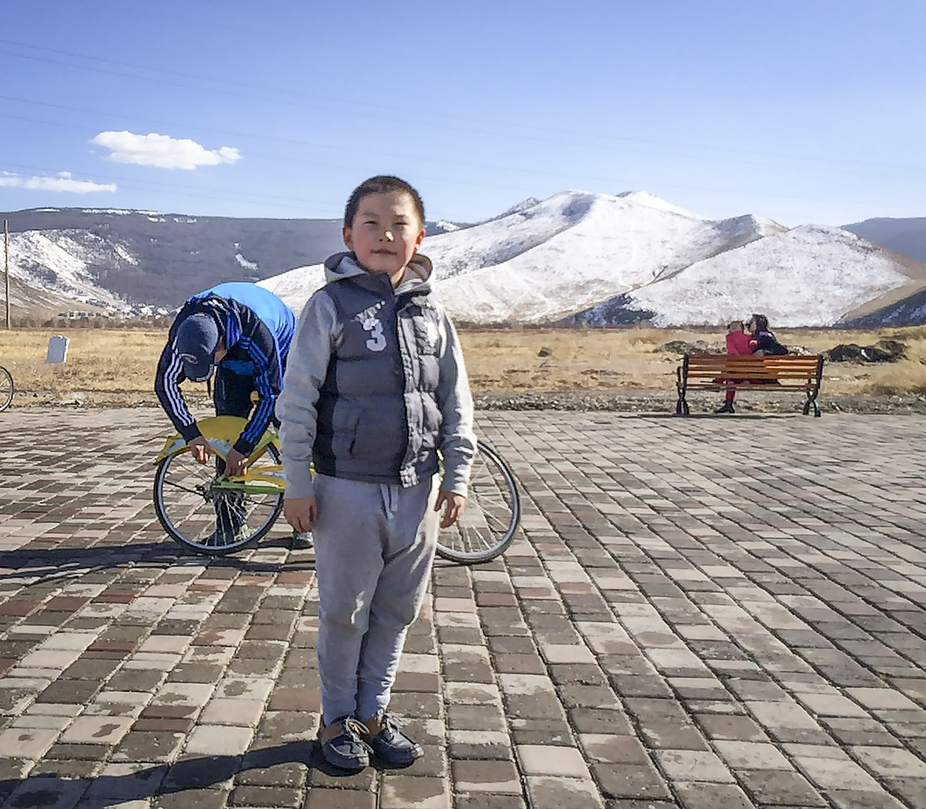
On the Road……Ulaanbaatar’s “National Park”
 Show on map
Spring has sprung in the world’s coldest capital!
It was a beautiful day spent exploring the bicycle road bordering Ulaanbaatar’s new National Park just south of the city. This young Mongolian boy is checking me out while his father tries to unstick his bicycle chain, which had jammed between the rear hub and the dropouts.
In the far background you can see parts of Bogd Khan Uul national park, which is the oldest national park in the world. It predates Yellowstone by over 100 years. The peak is over 7400 feet in elevation.
-Nathan
On the Road……A Few Days in Kyoto

Kyoto!
What an awesome city to travel by bicycle. I rented a bike from my hotel and had no trouble getting wherever I needed to go — coffee, ramen and sushi shops, Uniqlo, museums, gardens, and the famous Cycles Grand Bois.
More pictures to come.
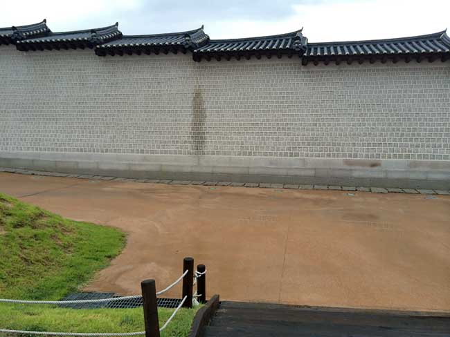
Random Images……Gyeongbokgung Palace Gate
Random Images……Memorial Day weekend, Pt. Covelo
Wow it’s been four years since I posted this other Memorial Day image. It’s one of my favorites, but as is typical with the “Random Images” category, it’s just a pleasing photo with nothing to do with bicycles.
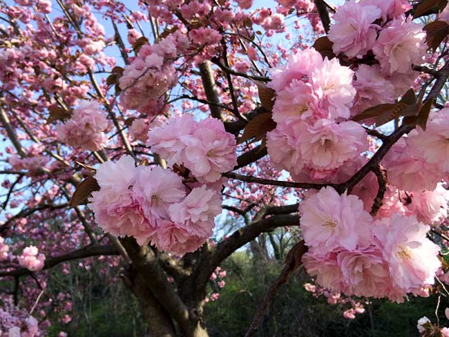
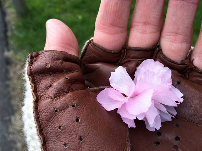
On the Road……Cherry Bloosoms are (were) Peaking in VA

Everyone is eager to call the peak, or predict the peak, or declare they saw the Cherry Blossoms at their peak. It doesn’t matter if you are in Washington DC or in Japan — it’s the same.
I’m in no position to do any of these things because I have a hard time recognizing the difference between a cherry blossom and a plum blossom.
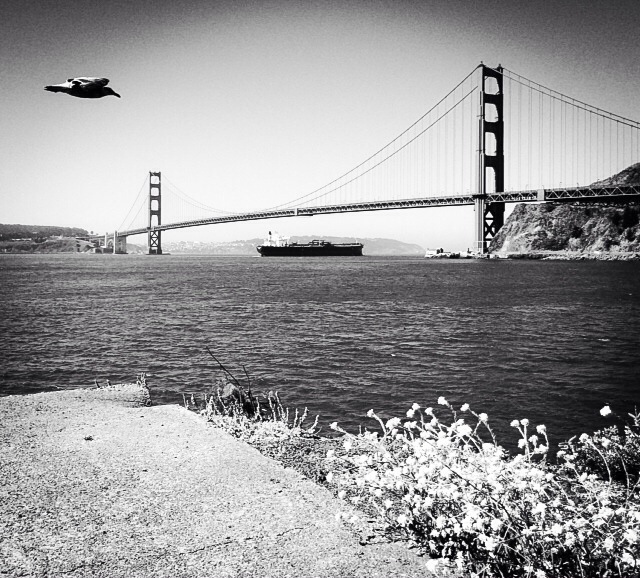
(editor’s note: I wrote about Ume and Sakura — the Japanese words for plum and cherry trees — in San Francisco’s Golden Gate park awhile back.)
However, about a week to a week and a half ago the weather was in the high 60s low 70s in northern VA. Now, I’m a bit hesitant to make the call but…I swear the cherry blossoms were at their peak!
I was riding my bike to work all week. Even though I was running late on this particular day, the landscape was so compellingly beautiful I stopped to make these pictures.
Below are some close-ups of the blossoms and the petals. Because of the small notches at the top of the individual petals, I believe these are, indeed, cherry blossoms.
Can any of my botanically-minded friends help me out here?
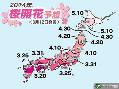
Finally, here is a map that I think shows the 2014 forecast for Sakura, including when and where they are blossoming across Japan’s different climate zones.
It looks like until May 10th there’s still time to see Sakura in the far north around Hokkaido.
-Nathan
On the Road……The Life Aquatic: Marshall, CA

If people ask me my favorite town in Marin County, I answer Marshall.
I do it for the puzzled look I inevitably get since few people have heard of the little community that has a population somewhere between 50 and 400.
My second favorite? Dogtown, with a population of 30.
On the Road……Golden Gate Bridge lookout

These folks know how to enjoy a Saturday afternoon Bay Area bicycle ride Fridaycyclotouriste-style!
They are proof that the bicycle can be a means to enjoying the outdoors, the sensations of the seasons, and good food — in addition to the often hyped and well-known cardiovascular and athletic benefits.
These Spanish-speaking visitors (from Spain and Colombia) are luxuriating in the beautiful Bay Area Fall weather (yes, it’s Autumn, hence the lack of fog on the Bridge).
I count five people in this picture, but there was a sixth. She was in deep siesta, curled up under a jacket behind the bicycle on the right and was not to be disturbed by this pesky photographer.
Thanks for the photo op and enjoy your visit good people of Europe and S. America!
-Nathan
Random Images……Paved Desert Landscape w/ Catalina Mtn’s

I didn’t get much bicycle riding in during 2011 due to distractions (like my job and other photography projects) and the natural fall-off that came along with moving to an auto-centric city with a hot desert climate. I’m not sure what 2012 will produce. A multi-day bicycle tour would sure be fun. Europe would be great.
One thing that is clear: since I began this blog in early 2009, the so-called bicycling movement has gone from a niche activity to a fully mainstream cultural phenomenon. Core77 has an interesting year-end review titled How the Cycling Movement Gained Momentum in 2011.
Anyhow, today’s landscape image was made while riding through the parking lot of the El Con Mall (home to Target, Home Depot, and a 20-screen cineplex). I didn’t have a reason to post this during 2011, but I enjoy the photo so I’m making it my 2012 New Year’s Day image.
I hope everyone has a year full of joyful bicycle riding with family, friends, and loved ones.
Happy New Year!
Nathan
Random Images……El Tour de Tucson is today – have a good ride!

Today is the 29th annual El Tour de Tucson — a 111 mile ride around the perimeter of the city.
This image has nothing to do with the Tour…(It was made on 4th Ave. last week-end)…but I really dig it!
Plus, for days afterward my housemates and I could not stop belting out Taaacooo Barrachooo in absurd operatic fashion.
Click below to hear award winning singer-songwriter and Bay Area troubadour, Forest Sun, giving his rendition:
Nathan
On the Road……Spotted on 4th Ave: a classic Fuji mixte

I love mixtes and I often ride one despite the tendency of people to connote them with “ladies” or “girls” bikes.
In fact, I wrote about mixtes — their practicality and how they relate to my sense of manhood — in a post a couple years ago which you can read here.
Nathan
On the Road……San Xavier Mission, architectural details II

Wikipedia’s architecture notes:
Outside, San Xavier has a white, Moorish-inspired design, elegant and simple, with an ornately decorated entrance. No records of the architect, builders, craftsmen and artisans responsible for creating and decorating it are known. Most of the labor was provided by the local Indians, and many believe they provided most or all of the artisans as well. Visitors entering the massive, carved mesquite-wood doors of San Xavier are often struck by the coolness of the interior, and the dazzling colors of the paintings, carvings, frescoes and statues. The interior is richly decorated with ornaments showing a mixture of New Spain and Native American artistic motifs.
The floor plan of the church resembles the classic Latin Cross. The main aisle is separated from the sanctuary by the transept or cross aisle, with chapels at either end. The dome above the transept is 52 feet (16 m) high supported by arches and squinches.
Featured Comment by Laura: “My grandmother Dorothy, who lived near Tucson for many years, was a devout Catholic, had her children educated by the Jesuits, and especially loved San Xavier. After she died, I made a pilgrimage and fell in love myself. She would have so enjoyed these photos! I especially like your St. Francis statue picture. Also, the word “squinches.”
Nathan replies: Yes, squinches. This was a new word for me. All I could think of to relate them to were the flying buttresses used in Gothic cathedrals, but apparently they serve a different function.
Route Map……Sabino Canyon Trail with elevation chart

Note to self: starting at my house — rather than the Sabino trail head — would make this an interesting 30 mile ride.
On the Road……Tucson Front Yards (more)

FOR SALE…$25…FIRM, which begs the question: the mattress or the asking price? Or both?
On the Road……Atop the Bolinas Ridge at Civil Twilight

This image from my recent ride along the Bolinas Ridge captures the specific time of the evening — civil twilight — when ambient light takes on a lovely bluish hue prized by painters and photographers.
Twilight, broadly speaking, refers to the time between sunset and dusk AND the time between sunrise and dawn (the chart below is a helpful tool for visualizing this).
But twilight (both morning and evening) is divided, more scientifically, into civil, nautical, and astronomical segments based upon the number of degrees the center of the sun is below the horizon (6, 6-to-12, and 12-to-18 degrees respectively).
Evening nautical twilight (nautical dusk) is said to end once sea navigation via the horizon line is no longer possible. Evening astronomical twilight (astronomical dusk) ends once the dimmest celestial objects (e.g. galaxies and nebulae) become properly visible to astronomical observation.
Commentary: in the context of the virtual world of Texting, Tweeting, and Tagging (from which I claim no exception) it feels palpably iconoclastic (if not downright subversive) to patiently witness our solar system’s sun disappearing ever so gently beyond the planet’s watery horizon.

Chart delineating Dusk, Dawn, and Twilight
Featured Comment by Shoeless Joe: “There is a biological connection, too, as the rods and cones in our eyes perceive light differently at twilight. It is called the Purkinje Shift (or Purkinje Effect). Wikipedia has a good article on it. One of the beauties of cycling is that it affords many opportunities to “patiently witness” the world around us in a way that is unique to the sport.”
Ride Report…A Late Fall Ride and a Pacific Ocean Sunset

I somehow got it into my mind that I needed to see the Pacific Ocean.
The solution was a 25 mile loop — from Fairfax up to and along Bolinas Ridge offering winding roads; steep climbs; fast descents; water and commanding Pacific Ocean views; relatively few cars; redwood forests; oak-studded grasslands; colorful autumn foliage; and, a smattering of wild life (I saw a coyote on top of the ridge and several deer on the way down).
In other words: there’s a bit of everything on this ride.
I departed around 3:30 pm (it’s getting dark by 5:30 pm) so I attached a headlight that I bought for my Brompton folding bike on the Guerciotti. I packed a persimmon and a wool turtleneck in my handlebar bag and wore a wool t-shirt and wool knickers. The weather, however, was unseasonably warm and I was comfortable for most of the ride in just the t-shirt. (Toward the end of the ride, I draped the sweater around my shoulders and tied the sleeves in a loose knot to keep it from slipping.)
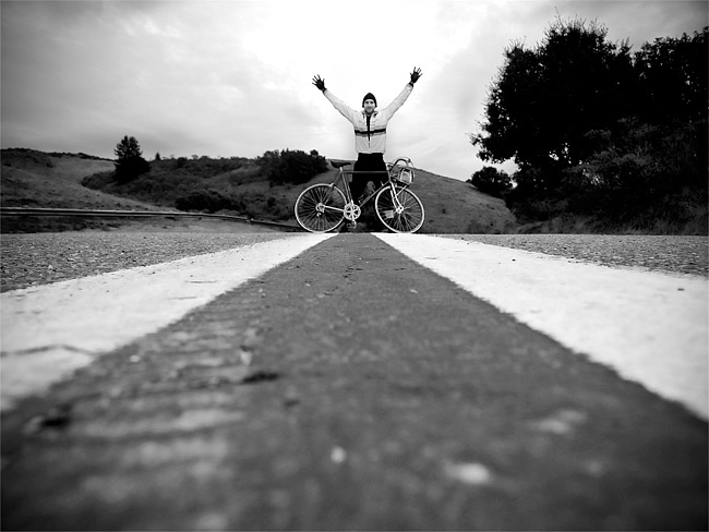
I spent most of this ride chasing the sun. I’d catch it, then it would dip behind a ridge. This continued until I got to the final, long climb with the sun well hidden behind the ridge. But as I slowly pedaled up the road — and the 1000′ vertical feet of switch-backs — I realized that at the very top the sun would make a final appearance.
As the image shows, I caught the sun for the final time as I rode atop the ridge.
So what about the bicyclist in the picture?
I passed him about 6 miles earlier, but since I’m always on-and-off my bike making photographs he caught up with me (think of the tortoise and the hare). When I noticed him climbing up the ridge about 100 yards behind me I set-up for this photo.
As the tortoise passed me, I exclaimed, “That’s a beautiful picture!” The tortoise turned briefly toward the sunset and replied, “it’s not real”.
At first I thought he was referring to the almost hyper-real colors (you know how sometimes nature reveals scenes — especially cloud formations and sunsets — that would be unbelievable had you not witnessed them with your own eyes?).
But on further reflection, maybe he was referring to photography itself and the philosophically problematic nature of attempting to reproduce reality with a machine!
Anyhow, I lingered on the ridge for 10-15 minutes and watched the sun dip below the horizon. Mosquitoes bit my arms and legs. I devoured a persimmon then turned on my headlight and rode home.
Random Images……Halloween Day – Redwood duff – Cataract Trail

An image that really has nothing much to do with bicycles (like many of my other “Random Images“), but it feels very autumnal and fitting for the holiday.
This was made on the way up the Cataract trail toward Mt. Tam.
In months past, I’ve written extensively about the area around Cataract.
On the Road……The Warming Hut, San Francisco
These are vistas from near The Warming Hut — a touristy, but perfectly located place to stop for a snack (at either the picnic tables or at the cafe).
I didn’t try their coffee, so I cannot comment…Perhaps next time.

 Beyond the bicycles, a little of the San Francisco skyline is visible (note the gold dome of the Palace of Fine Arts).
 That’s not my coffee cup, really.
On the Road……SF’s Golden Gate Bridge, Westside, North Tower

On the Road……Guerciotti on the Golden Gate Bridge

I recently did some exploring around the Golden Gate Bridge (and down by The Warming Hut).
This view is from the western side of the bridge looking toward the south-west. I believe the Seacliff/Richmond neighborhood is visible in the background.
Random Images……Another View of Mt. Tam from the Marsh

Random Images……Corte Madera Tidal Marsh

Since my previous post highlighted this marsh, I thought I’d share a B&W image made with an old Fuji S2 digital camera. The view is from deep in the marsh looking west toward Mt. Tam across tussocks of Pampas Grass (Cortaderia selloana). Over the course of a couple weeks, I made a series of images in this area last spring. This was one of my favorites.
On the Road……Ferryboat Plying the SF Bay, Tiburon

From Shoreline Park in Tiburon, looking southwest with Belvedere “island” and the Golden Gate Bridge in the background
On the Road……San Francisco Bay’s, Angel Island

I bicycled to Angel Island (via ferry) over the long holiday week-end. It was a typical July day on the San Francisco Bay — patches of brilliant sunshine mixed with belts of fog and massive wind gusts, due to cold ocean air being sucked into warmer inland areas.
The image above was made on the SW side of the island below the summit of Mount Caroline Livermore (El. 788′). Note downtown SF, Alcatraz, and the Golden Gate Bridge in the background. (You can click on the image for an expanded view).
(Wikipedia fact: Angel Island was part of the mainland until about 10,000 years ago, when sea levels rose as the last ice age came to an end.)
More images, a map, a short ride report, and an espresso review to come.
Random Images……Summer Solstice!
To celebrate the Summer Solstice (the longest day of the year and the exact moment — 11:28am PST yesterday — when the earth’s axial tilt is most inclined to the Sun) a gallery of images of Spring flora made on various bicycle rides over the last couple months:

From upper left-to-right and from top-to-bottom:
- Daisies of some kind;
- Sticky Monkey Flower (Mimulus aurantiacus);
- native California Black Oak (Quercus kellogii);
- native Miner’s Lettuce (Claytonia perfoliata);
- a native Pacific Coast Iris;
- native California Poppy (Eschscholzia californica);
- another Pacific Coast Iris,
- a Rose; and finally,
- Scotch Broom (Cytisus scoparius) a troublesome invasive species supposedly wreaking havoc upon on native wildlife ecosystems.
On the Road……Back Porch, Memorial Day 2010

Another random image made on my back porch. Like this picture also from my porch (or this Christmas Day image), it really has nothing to do with bicycles — just an interesting photograph I thought I’d share.
The above image was made with my new (used) camera: a Fuji S5. The lens is a Nikon 18-55mm picked up for $25 on craigslist. The autofocus motor on the lens is broken (which is why it was so cheap), but I like it because it forces me to slow down and focus the lens by hand.
On the Road……Heading toward Azalea Hill Pass

On the Road……St. Rita’s Church in Fairfax

April 13th. I can’t put off doing my taxes any longer. So I take a quick ride to my local library to pick up some tax forms.
After I get my forms, I’m suddenly struck by the view looking across the street at St. Rita’s Church.
Time to make a quick portrait of the Nishiki Mixte, I think.
For better or for worse, this pretty much sums up the way most of my photos come about: spontaneously and a quite randomly.
On the Road……Sorich Ranch Park, below San Rafael Ridge
March showers bring April flowers…just down the street from the dog park!

Not sure the species, don’t think they’re native.
Cape Daisies, originally from the South Africa, according to my botanist friend, Laura.
On the Road……Near West Portal, San Francisco

On the Road……Azalea Hill pass (EL 1,080′)
The making of this photo: (1) place camera directly on road (2) set the 10 second timer (3) grab bike (4) run into the frame and hope to hit a good mark to optimize composition and hope for no cars (5) wait for shutter to fire — still hoping for no cars to come up from behind (6) get the camera and myself off the road as quickly as possible.
I tried this twice (this was the first). It worked just as I had hoped!
Azalea Hill pass
This is an important spot — the intersection of Bolinas-Fairfax and Pine Mountain (fire) roads. Mountain bikers and hikers will often drive here to start at the trail head; road bicyclists will often rest and take water here.
By all means, make the short 10 minute hike from this pass to the top of Azalea Hill (EL 1,217′). You’ll be rewarded with a 360 degree vista including a great view of Mt. Tamalpais and Bon Tempe lake and sight lines extending across the bay to the Campanile on the UC Berkeley campus and continuing on to Mt. Diablo.
On the Road……Rain, Rain, Rain
In between rain showers I went for a little ride around downtown Fairfax today. I spied this cruiser, parked under an awning to keep it dry, I guess. Not even a lock! It’s all good.

On the Road……Happy New Year!
The Friday Cyclotouriste wishes everyone a happy New Year’s Day, 2010. As you spread the joy and benefits of riding bicycles this year may you suffer few flats, encounter many interesting people, consume delicious food and drink, and experience only tailwinds during all your rides!

On the Road……Fairfax Loop via Mill Valley and Panoramic Hwy

Bay Area on 12/05/09! Got to love the sunshine. And what a picture postcard vista.
You too can find the spot by clicking on the map link under the photo.
In the background are a few of the storied “seven sisters” — a series of beautiful rolling hills. Some are actually quite steep and not so rolling (see also here and here for a few more images of this stretch). I tend to get distracted by the scenery and want to get off my bike and have a little wine, cheese, dried fruit, or whatever else I’ve stowed in my big, roomy front handlebar bag!
On the Road……Civic Center Farmer’s Market

On the Road……Bolinas Lagoon Meets Pacific Ocean

The turnaround point of my ride: the mouth of the Bolinas Lagoon.
(For a cool aerial perspective of this spot, click the geotag under the image then click the satellite map and zoom to taste!)
On the Road……Back Porch

We had some heavy October rains and my riding trailed off (I’ll admit to sometimes being a fair weather cyclist). This image was made on my back porch between rain showers.
On the Road……Duxberry Reef, Bolinas

A preview of the ride I’m planning this week: Duxbury Reef tide pools.
I made these photos last December during a 2-hour window right before sundown.
On the Road……Santa Cruz, a few more photos

I wanted to bicycle out to the coast today, but a heat wave (103 degree F) made me rather lethargic. So here’s a few unpublished images from my recent Santa Cruz trip.
My brother (pictured) and I like this image because of its enigmatic time and geography: The Macedonian coastline, early 1960s perhaps.
For the actual location, remember to click the geotag icon below the image and use the zoom and map tools (switching to the satellite map type and zooming in very close is always interesting).
His bike is a really nice, old lugged Trek. That’s an Ostrich Bag on the front and a home-made pannier bag on the back.
On the Road……Heading South, Golden Gate Bridge

It may not look so, but it was foggy, cold, and very windy this morning. I was comfortable only after putting a windbreaker over two wool layers.
Also, we found out the bike path on the west side of the Golden Gate Bridge is closed during the week.
Whoops!
This made entering and exiting the bridge a little more complicated.


