Archive for the ‘ridgecrest blvd’ tag
Bicycling Culture……”Le Velo” and “I’m on a (mother-bleeping) Bike”
Two video parodies — that I’m assuming were made by bicycling enthusiasts — which mock the unfortunate pretentiousness so often demonstrated by certain classes of cyclists.
The first video is from the lycra-clad Euro-racer’s perspective. There’s some hysterical satire in here. The first thirty seconds are quite rich and there’s another sequence from about the 1:30 to 2:00 minute mark that had me rolling on the floor (“Le Pelotan!”).
By the way, this was clearly filmed on Panoramic Highway or Ridgecrest Blvd. overlooking the Pacific Ocean. If you’re interested, I’ve posted many images of this gorgeous stretch of road on this blog.
The second video is presented from the righteous, urban cyclist’s perspective. Mind you the video is what is called — NSFW — not safe for work — due to the rather crude, in your face language.
But if you’re interested, check it out on YouTube, where some people seem to think the video is celebrating bad behavior rather than calling these kind of cyclists out.
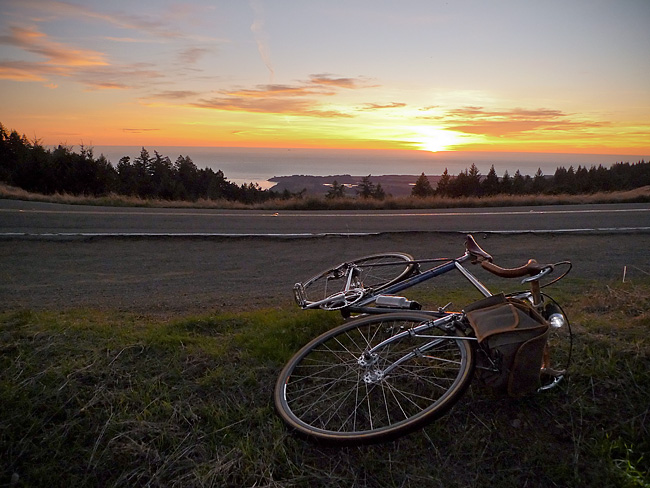
On the Road……Atop the Bolinas Ridge at Civil Twilight

 Show on map
This image from my recent ride along the Bolinas Ridge captures the specific time of the evening — civil twilight — when ambient light takes on a lovely bluish hue prized by painters and photographers.
Twilight, broadly speaking, refers to the time between sunset and dusk AND the time between sunrise and dawn (the chart below is a helpful tool for visualizing this).
But twilight (both morning and evening) is divided, more scientifically, into civil, nautical, and astronomical segments based upon the number of degrees the center of the sun is below the horizon (6, 6-to-12, and 12-to-18 degrees respectively).
Evening nautical twilight (nautical dusk) is said to end once sea navigation via the horizon line is no longer possible. Evening astronomical twilight (astronomical dusk) ends once the dimmest celestial objects (e.g. galaxies and nebulae) become properly visible to astronomical observation.
Commentary: in the context of the virtual world of Texting, Tweeting, and Tagging (from which I claim no exception) it feels palpably iconoclastic (if not downright subversive) to patiently witness our solar system’s sun disappearing ever so gently beyond the planet’s watery horizon.

Chart delineating Dusk, Dawn, and Twilight
Featured Comment by Shoeless Joe: “There is a biological connection, too, as the rods and cones in our eyes perceive light differently at twilight. It is called the Purkinje Shift (or Purkinje Effect). Wikipedia has a good article on it. One of the beauties of cycling is that it affords many opportunities to “patiently witness” the world around us in a way that is unique to the sport.”
Ride Report…A Late Fall Ride and a Pacific Ocean Sunset

I somehow got it into my mind that I needed to see the Pacific Ocean.
The solution was a 25 mile loop — from Fairfax up to and along Bolinas Ridge offering winding roads; steep climbs; fast descents; water and commanding Pacific Ocean views; relatively few cars; redwood forests; oak-studded grasslands; colorful autumn foliage; and, a smattering of wild life (I saw a coyote on top of the ridge and several deer on the way down).
In other words: there’s a bit of everything on this ride.
I departed around 3:30 pm (it’s getting dark by 5:30 pm) so I attached a headlight that I bought for my Brompton folding bike on the Guerciotti. I packed a persimmon and a wool turtleneck in my handlebar bag and wore a wool t-shirt and wool knickers. The weather, however, was unseasonably warm and I was comfortable for most of the ride in just the t-shirt. (Toward the end of the ride, I draped the sweater around my shoulders and tied the sleeves in a loose knot to keep it from slipping.)
I spent most of this ride chasing the sun. I’d catch it, then it would dip behind a ridge. This continued until I got to the final, long climb with the sun well hidden behind the ridge. But as I slowly pedaled up the road — and the 1000′ vertical feet of switch-backs — I realized that at the very top the sun would make a final appearance.
As the image shows, I caught the sun for the final time as I rode atop the ridge.
So what about the bicyclist in the picture?
I passed him about 6 miles earlier, but since I’m always on-and-off my bike making photographs he caught up with me (think of the tortoise and the hare). When I noticed him climbing up the ridge about 100 yards behind me I set-up for this photo.
As the tortoise passed me, I exclaimed, “That’s a beautiful picture!” The tortoise turned briefly toward the sunset and replied, “it’s not real”.
At first I thought he was referring to the almost hyper-real colors (you know how sometimes nature reveals scenes — especially cloud formations and sunsets — that would be unbelievable had you not witnessed them with your own eyes?).
But on further reflection, maybe he was referring to photography itself and the philosophically problematic nature of attempting to reproduce reality with a machine!
Anyhow, I lingered on the ridge for 10-15 minutes and watched the sun dip below the horizon. Mosquitoes bit my arms and legs. I devoured a persimmon then turned on my headlight and rode home.
Route Map……Ridgecrest Boulevard with Pacific Ocean View
Northern California just had a glorious little heat wave. This last gasp of Indian Summer resulted in hot sunny weather with temperatures in the 70’s, and even 80’s, over the week-end.
And for some reason, I got it into my mind late Sunday afternoon that I had to ride until I could get a view of the Pacific Ocean.
The easiest way to accomplish this goal was a 25 mile round-trip with about 2,600′ of vertical climbing.
Here’s a route map and a one-way elevation profile from the ride:
The spit of land in the above image (just past the line of trees) comprises the town of Bolinas and the Pt. Reyes pennisula.
More pictures and a short ride report to follow.
On the Road……Fairfax Loop via Mill Valley and Panoramic Hwy

Bay Area on 12/05/09! Got to love the sunshine. And what a picture postcard vista.
You too can find the spot by clicking on the map link under the photo.
In the background are a few of the storied “seven sisters” — a series of beautiful rolling hills. Some are actually quite steep and not so rolling (see also here and here for a few more images of this stretch). I tend to get distracted by the scenery and want to get off my bike and have a little wine, cheese, dried fruit, or whatever else I’ve stowed in my big, roomy front handlebar bag!
On the Road……Fairfax Loop via Mill Valley and Panoramic

A Prius ad was being shot at the top of Bolinas Road and Ridgecrest.
On the Road……Panoramic Highway-to-Mill Valley

12/05/09: Current and former New York City Bicycle Club members Tania, John, and Carmen. Tania was in town for a visit. John and Carmen now live in SF. I did my best to keep up with these fast club riders during a very hilly 35-40 mile loop to and from Fairfax via Panoramic Highway and Mill Valley. (Here’s a map of the route.)
On the Road……Approaching Ridge Crest

Nearing the ridgeline above Alpine Lake, Bolinas-Fairfax Rd. is about to intersect Ridgecrest Blvd. (hardly a Boulevard, in the traditional sense, look here for views of this so-called Boulevard).
Bear to the left to gain another 1000′ of elevation and to head toward the summit of Mt. Tamalpais (click here for some images from that ride) or bear to the right to lose 1500′ and descend to the Pacific Ocean and the town of Bolinas.
Bolinas is a famous haven for artists, writers, musicians, and philosophers and the first place I lived when my family moved to California from the mid-west.
Ride Report……Fairfax-to-Bolinas
The Bay Area is having a great Indian Summer. Temperatures nearing 70 degrees, negligible wind, and no fog.
A great excuse to ride out to the ocean: Fairfax to Bolinas (check out the route and elevation profile).
The summary:
The ride is about 35 miles round trip with roughly 4,000 feet of hills to climb. The first eight miles cover the route to Alpine Lake, but by continuing up and over Bolinas ridge down to the ocean you add another 2400′ of climbing (and 20 additional hard miles) to that round trip.
I left the house around 12:15pm, but turned around just after leaving to fetch my cheap, plastic windbreaker. For most of the day I wore just a lightweight merino wool t-shirt and a pair of wool knickers (from Bicycle Fixation) with a heavier long-sleeve wool pullover and the windbreaker in reserve.
Loaded for the day, the Ebisu is no lightweight and my largest rear cog has only 27 teeth. Suffice to say I suffered greatly climbing the 1500′ Bolinas ridge on the way back. The truth is, I’m just not in top cycling shape this season and these kind of climbs are serious work.
In terms of food I brought: 2 PB&Js, a honey crisp apple, a couple slices of Havarti cheese, and two water bottles. In hindsight, this was a bare minimum; I should have brought more.
On the way out to the ocean, I stopped briefly at Ridgecrest Blvd, but otherwise rode straight to the coast in less than two hours. Now quite hungry, I ate one of my sandwiches and the cheese. It was good I didn’t eat more, because I would need every remaining morsel for the return trip.
Climbing back up to Ridgecrest (after relaxing at the beach in downtown Bolinas for 20-30 minutes), I starting losing all my power and I could hear Velocio’s words inside my head (never ride to the point of exhaustion; eat before you are hungry, etc., etc.).
Discouraged, as I was within a mile of the top, I nevertheless got off my bike to avoid bonking. Dizzy and seeing spots (at this pullout), I ate an apple and half of my last PB&J (saving the final half a sandwich for the energy boost I’d need to climb the last hill of the ride before descending home into Fairfax). Within five minutes, I felt good enough to continue.
I was super stoked, however, that I brought that plastic windbreaker, because as I flew down Bolinas Rd. in total shade I was amazed how cold my body had become (despite the day starting off so sunny and warm). With the sun getting low, around 4:30pm, I slipped the plastic windbreaker over both wool layers on the final steep descent (which is 4 miles long and where speeds can exceed 35 mph) and was very, very happy…and when I arrived home: very, very tired.
On the Road……More Panoramas, Ridgecrest to Mt. Tam

On the Road……The Seven Sisters

Riding toward the summit of Mt. Tam, I struggled to maintain momentum over the series of seven undulating hills, known as “The Seven Sisters” (scroll down to the bottom of this page for more details on the sisters).
Apparently, 90% of all North American car commercials are filmed along this stretch of roadway. I’ve only seen filming once twice.

