On the Road……Mill Valley, Boot Coffee Consulting
This Friday’s ride was a short commute to Mill Valley and since I forgot my camera I’m including a map instead.
There are many possible routes using little side roads and bike paths, but these bike paths are not visible on Google maps, hence the gaps between the red route lines.
I left a little past 8am and rode at a slow, meandering pace for about an hour. My destination was an intensive specialty coffee training workshop with Willem J. Boot of Boot Coffee Consulting, a remarkable fellow with a true mastery of his subject. The state-of-the-art, teaching studio (equipped with numerous roasters and high-tech coffee industry gadgetry) is continuously abuzz with instructional exercises laid out in ritualistic fashion by Willem’s able associate, Jodi.
The class was also graced by a special guest, Graciano Cruz, of Los Lajones estates in Panama who spoke of his efforts to raise the quality level of coffee and with it the lives of the region’s indigenous farmers (see this description of his world class coffee).
Overall, it was a fantastic course during which I was treated to a cupping of the fabled Gesha coffee from Panama, as well as some delicious Ethiopian, Kenyan, Guatemalan, and Taiwanese (yes Taiwanese) samples. The location of the Boot Coffee school is marked by the southern most of the blue placemarks on the above map.
(Note: The Friday Cyclotouriste’s espresso reviews may need a complete overhaul now that my sensory awareness of coffee has been exposed to Mr. Boot and the SCAA and CQI criteria.)
The other placemarks on the map pinpoint two other highlights of this ride: (1) my closest encounter yet with a Red-Tailed Hawk (only about 20′ away sitting in a nearby tree) and (2) a voluminous patch of black berries that I stopped to gorge on during the evening ride home.
On the Road……Heading to Santa Cruz, Hwy 1

 Show on map
Looking northwest, past Devil’s Slide along Highway 1.
Espresso Review……Whale City Bakery, Davenport

SUMMARY (84 out of 100 points): Was it because of the 80+ miles of hard riding that preceded it or was this, in fact, a very good espresso in its own right? Separating the two is tricky (you know how everything tastes great when you’re out hiking or camping–same thing with a bike ride of this length).
I have to say I think Whale City Bakery gets much right with its espresso. The presentation was acceptable. The crema was decent though not stellar (a little thin actually), but the flavor really shined through. I’m not one that easily identifies the acidity or flavor attributes (like floral, citrus, malt, etc.) of each cup. Nonetheless, the overall taste just seemed right–clean, balanced, yet also interesting.
Because I was curious the Barista retrieved the foil bag of espresso—apparently a local Santa Cruz purveyor, whose name I unfortunately failed to make a note of and have now forgotten.
Taste (5/5)
Crema (4/5);
Serving size (4/5);
Presentation (4/5);
Eco-friendliness (4/5)
![]()
![]()
(If you haven’t already done so check out The Friday Cyclotouriste’s espresso rating system).
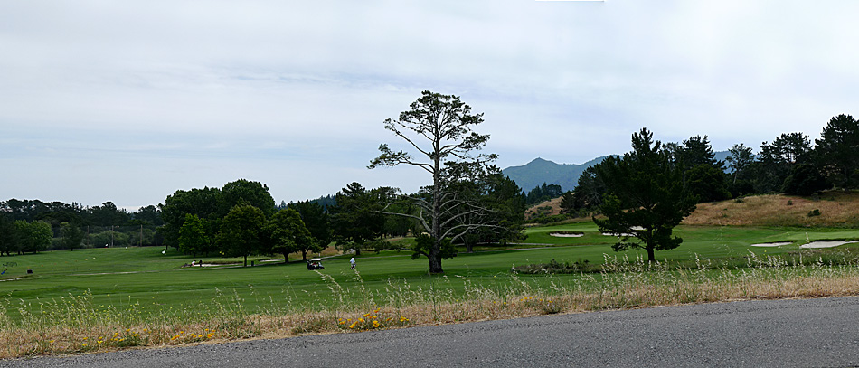
Ride Report……Heading To Santa Cruz, Part II

The route was prety straightforward. If you’re not familiar with the Bay Area you should print out some maps, but we basically made our way from memory.
The trip breaks down roughly into three sections.
Mile 0-35: a mix of urban and suburban roads and bike paths which wind through Marin cities such as San Anselmo, Ross, Corte Madera, and Sausalito. You cross the Golden Gate Bridge and head west toward the coast and climb Skyline Blvd. before enjoying a nice descent into the city of Pacifica.
Mile 35-50: the long climb outside of Pacifica past Devil’s Slide offers some spectacular coastal views on the descent. Then it’s mostly flat or gentle low rolling hills to Half Moon Bay (which is a good place to remember to eat something or at least stock up on food).
Mile 50-100: a lot of short steep hills in this section makes it difficult to maintain much momentum. Also there’s no running water at the numerous coastal campsites, but Pigeon Point Lighthouse will let you use their hose spigot to refill water bottles. A few miles past the lighthouse is Gazos Grill in Pescadero, which will serve you a meal. Then there’s Davenport (see my espresso review). Finally, in the last 14 miles or so, the hilliness decreases as you roll past fields planted with brussel sprouts and begin to hit the outskirts of Santa Cruz. We crossed town, mostly on bike paths, to arrive at our friend’s house near the boardwalk where we would stay for the night.
Note: the picture above is of my brother along the climb outside of Pacifica. It’s steeper than it looks, the shoulder is quite narrow, and there’s lots of truck traffic heading up to the construction project where a massive new tunnel is being built.
Read Part I here
On the Road……Heading South, Golden Gate Bridge

It may not look so, but it was foggy, cold, and very windy this morning. I was comfortable only after putting a windbreaker over two wool layers.
Also, we found out the bike path on the west side of the Golden Gate Bridge is closed during the week.
Whoops!
This made entering and exiting the bridge a little more complicated.
On the Road……Heading to Santa Cruz, Mill Valley

Since we didn’t eat breakfast. A picnic table by this Mill Valley park, 35 minutes into the ride, was our first stop.
Route Map……Fairfax-to-Santa Cruz
Ride Report……Heading to Santa Cruz

A hastily arranged portrait of my fully-loaded Ebisu just before setting out (around 6:30am) for the trip to Santa Cruz.
From Fairfax it is almost exactly 100 miles, one way. My brother and I decided to make the trip in a day.
A few years ago, I covered the same distance, but took two days stopping to camp on the beach near Half Moon Bay. This time there would no camping and I would either pedal back after a rest day or catch a ride back to the Bay Area from our friend in Santa Cruz.
Despite it being just a long day ride, I attached pannier racks to my existing front rack and packed like it was a short tour. For clothes, I had wool riding pants, an extra pair of pants and a short-sleeved collared shirt for my day off the bike, a wool t-shirt, a wool pullover, 2 pair of wool socks, a rain/wind layer, a wool beanie, a baseball cap, and (non-wool) underwear. I pedaled in Adidas Sambas and also packed a pair of Rainbow flip flops and a swim suit for the Santa Cruz boardwalk.
As far as equipment, I brought a miner’s headlamp, two spare tire tubes, plastic tire irons, a bunch of zip ties, a bicycle multi-tool as well as a small selection of allen and other wrenches (to help with roadside repairs that might otherwise be difficult with just the multi-tool), a small digital camera, and a cell-phone and charger. I also brought a few toiletries in a small pouch: shampoo, sunscreen, and tooth brush.
For food, I packed 4 PB&J’s, 4 hard-boiled eggs, a mango, 2 apples, and 2 oranges. Plus, two water bottles.
Fully-loaded, the bike weighed in at around 55 lbs. I think the bike itself (with full fenders, racks, rear basket, lighting, and a handlebar bag) weighed around 30 lbs., which means I was carrying 25 lbs of STUFF. That seems like a lot of weight considering there would be no camping.
Think how heavy my bike would get if I added cooking, cleaning, and eating gear, extra food, a tent, and a sleeping bag!
Read Part II here
Gear Gallery……The Indomitable Ebisu
Long overdue, here is the official introduction to the companion to my Guerciotti. Heavily influenced by the designed of French cyclotouring machines of the 1940s, 50s and 60s, I commissioned this 59cm bike from Jitensha Studio in Berkeley.
I told Hiroshi, the proprietor, I wanted a versatile bike for light touring and brevets; I wanted the option of carrying 10-20 lbs. upfront on low-riding front racks; and, I wanted the frame based around the 650B wheel size (and 38mm tire width).
The build included both new and vintage parts including a SON front generator hub powering the headlight, integrated front and rear racks (including detachable low-rider pannier racks) and Honjo fenders, Brooks Team Pro TI saddle, Simplex retrofriction downtube shifters, TA cyclotouriste cranks, and Shimano Ultegra derailers. A Berthoud decaleur is used with the front handlebar bag, which was custom ordered from the Guu-Watanabe in Tokyo. I believe I was their first customer from outside Japan (more on that story here).
Now that I’ve been riding the bike for some time there are inevitably small tweaks I would consider: slightly more geometric trail so it handles better unloaded thereby making it more of an all-around bike (this would require a new fork), indexed shifters (to go with the 8-speed Shimano cassette) or a 6-speed freewheel (to go with the current Simplex shifters), and maybe some slight changes to the gear ratios (currently 47×34 front and 13-27 rear). I’m also eagerly awaiting a true 38mm wide tire from Grand Bois as a replacement for the Panaracer Col de la Via which actually measure 2mm less than 38mm.

Click to Embiggen
On the Road……Tomales Bay, Pt. Reyes

I’m sure everyone who passes by this old wreck makes a picture; it’s hard to resist.
The mouth of Tomales Bay and the mighty Pacific Ocean is identifiable by the small gap between land masses on the left side of the horizon.
Espresso Review……Priscilla’s Pizzeria, Invernes
SUMMARY (64 out of 100 points): Priscilla’s espresso is sort of the mirror image of the Station House Cafe in Pt. Reyes where the crema was great, but the espresso was overly voluminous. Here, I was served a perfectly-sized cup (drinkable in 5-10 sips) just like one gets at the counter of a French brasserie. Yet the crema was nearly non-existent; a cup of thin, black liquid…Alas, my quest for the perfect espresso continues.
On a positive note, like a lot of the places I’ve reviewed there is some great outdoor seating and the food looked delicioso. Lots of people were chowing down on good looking pizza and fresh local oysters (from Hog Island or Drake’s Bay).

Taste (3/5)
Crema (0/5);
Serving size (5/5);
Presentation (4/5);
Eco-friendliness (4/4)
Click below for the rest of the review:
Read the rest of this entry »
On the Road……Near Woodacre, ‘Si Se Puede’

Noticed this passing through Woodacre on the back roads returning from Tomales Bay and Inverness. Woodacre is home to Zoltron, a local graphic art studio.
On the Road……Lagunitas Bike Path, Redwoods

On the Road……Lagunitas Bike Path, Coho Crossing

Here’s a ‘salmon crossing’ sign along Lagunitas Creek. The creek meanders its way along the bike path shown here and out Tomales Bay to the Pacific Ocean. The watershed is home to the largest remaining population of endangered Coho Salmon (Oncorhynchus kisutch) on the central California coast. The fish spend 1-1/2 years out in the ocean growing to about 2 feet in length before returning to fresh water to spawn. I’ve done some work in the past for a local non-profit that’s trying to maintain what’s left of this population (the group is aptly named: SPAWN). There are salmon in other Marin creeks (such as in Redwood Creek in Muir Woods), but these arrive via San Francisco Bay (passing under the Golden Gate Bridge) rather than via Tomales Bay.
Route Map……Fairfax-to-Inverness
On the Road……Inverness

On the Road……Pt. Reyes Station

Here’s a slightly abstract image for a change: July 3rd, Toby’s Feed Barn (and sky), downtown Pt. Reyes Station.
On the Road……Pt. Reyes National Seashore

Are you getting bored with panoramas yet?
The novelty is starting to wear off for me, but they do give a pretty good sense of the landscape so I’ll keep composing these whenever the inspiration strikes (and I’m still quite thrilled with my first try at this format, originally posted here).
Espresso Review……Station House Cafe, Pt. Reyes
SUMMARY (64 out of 100 points): If only the Station House knew the proper size of a single espresso (a full shot glass is about right) they could have something here because the crema was very good (check out the color and the bubbles!) and the presentation was great. But the volume of espresso was so gigantic that all balance and harmony was lost.
Since the wind was howling, I took shelter indoors, but there’s a very appealing outdoor patio with space to park bikes. So even if the espresso is flawed this place is still a natural stop if you’re passing through Pt. Reyes Station and want a sit-down, restaurant experience.
Taste (4/5);
Crema (4/5);
Serving size (1/5);
Presentation (3/5);
Eco-friendliness (4/5)

Click below for the Full Review:![]()
On the Road……Woodacre

Lots of barbed wire fencing in West Marin. This particular barb was captured during a short rest before the final hill on the way home from Pt. Reyes.
On the Road……Olema, Highway 1

Olema is said to mean “Coyote” in the native coastal Miwok language. Long thought to be the epicenter of the 1906 San Francisco earthquake, the Olema Valley is where the Pacific and North American tectonic plates meet. So, geologically speaking, everything on the east side of the valley is in North America and everything on the west side is not (such as the Bishop Pine forest, behind and to the right of this barn).
On the Road……Lagunitas Bike Bridge

Here’s where the bike path on the way to the Pt. Reyes peninsula crosses over Sir Francis Drake Blvd. Most cyclists (at least those on racing bikes and super narrow tires) don’t use this path because there’s a few dirt stretches that are a little rough. On a cyclotouriste or randonneuring bike, it’s no problem to maintain good speed and relative comfort even on the rough stretches.
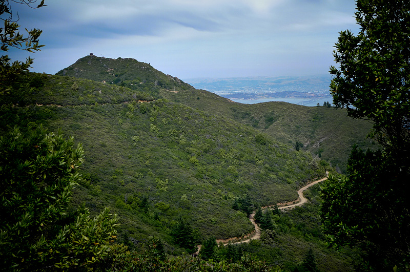
On the Road……More Panoramas Mt. Tam

click to enlarge
I couple weeks ago I posted my first panoramic image. I’m still intrigued by the photomerge feature of Adobe CS3.
On the Road……More Panoramas, Ridgecrest to Mt. Tam

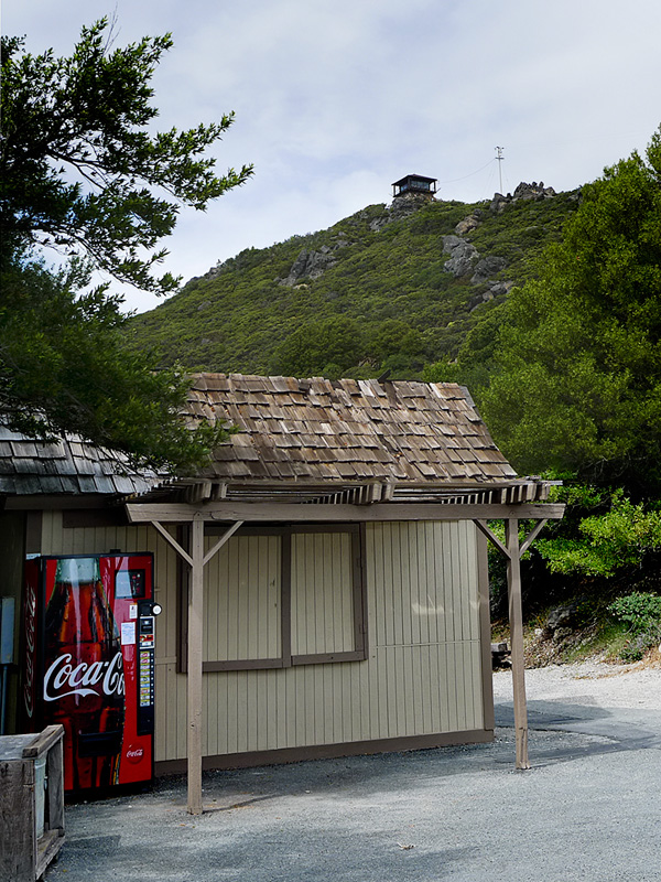
On the Road……View from the Peak

On the Road……View from the Peak

Out of deference to Chief Marin, the defeated Coast Miwok leader, I did not “summit” Mt. Tam (that is, I didn’t walk the final 100 yards up the path to the fire look-out) as legend has it the early Indian inhabitants avoided the peak.
The view is still epic. This is a cropped section from the full image. Notice downtown San Francisco jutting out into the bay (and the fog trailing in from the west) just above the head of the woman in the yellow parka standing on a newly constructed viewing platform.
On the Road……Heading Toward the Summit of Mt. Tamalpais
Here are a few views of Tam as one gets progressively closer to the summit.
From the Meadow Club above Fairfax the peak is visible in the far distance (image one). But following this route it goes out of view (with one or two fleeting exceptions) until the last few miles when the summit is once again in view (as seen in images two and three).
On the Road……The Seven Sisters

Riding toward the summit of Mt. Tam, I struggled to maintain momentum over the series of seven undulating hills, known as “The Seven Sisters” (scroll down to the bottom of this page for more details on the sisters).
Apparently, 90% of all North American car commercials are filmed along this stretch of roadway. I’ve only seen filming once twice.
On the Road……Heading Toward the Summit of Mt. Tamalpais

This fellow was just hanging out in the middle of the road. I don’t know how I spotted him (I guess I was just looking in the middle of the road.)
On the Road……Heading Toward the Summit of Mt. Tamalpais

The ever present Sword fern (Polystichum munitum) — one sign that you’re in a redwood ecosystem or on some north facing slope.
On the Road……Heading Toward the Summit of Tamalpais

Lots of variation in terrain on the way to the summit — from oak-studded grasslands and chaparral to the misty Douglas fir and Redwood forests around Alpine Lake seen above.
Route Map……Fairfax-to-Mt. Tamalpais
Ride Report……Summit of Mt. Tam

The recent post about Paul De Vivie inspired me to do something I’d never done before: bicycle from my house in Fairfax to the summit of Mt. Tamalpais. (Velocio’s seventh bicycling commandment, or one interpretation thereof, is to never ride without a purpose — see Velosophy.)
So today, I gave myself this purpose.
I left about 12:30pm and returned about 5:30pm. A three hour climb to the summit; half-an-hour at the top; and an hour-and-a-half to ride back. The summit is about 2,500′ in elevation, but starting from Fairfax you gain and give up (and gain again) much more elevation over the 35 mile round trip. Roughly 6,000 feet of total climbing is actually involved.
I carried two water bottles, two peanut butter and jelly sandwiches, and a few ounces of cheese and salami, which provided for three food stops.
The weather was partly sunny with an occasional breeze, some light rain, and pockets of dense fog. I had wool knickers, a wool tee-shirt, a long-sleeve wool pull-over, a rain jacket, a neckerchief, a baseball cap, and a wool beanie to counter the variable weather.
It’s mid-June but my cycling season is still young and I am not in great cycling shape yet so today — I suffered. I also forgot to re-fill my water bottles at the summit forcing me to conserve less than half a bottle on the return.
At two points — the steepest section right before the summit and the last major climb on the return — I was assisted by, of all things, a strong tailwind giving me just enough of a boost to get me up and over.
I could not help but wonder if this beneficence was the work of Saint Velocio watching over me.
On the Road……Road Kill, II

A couple weeks ago it was a small fawn (click here for that post) now a skunk.
I placed this guy off the road near a tree and covered him loosely with some sticks. Because the Marin County sky is filled with Turkey Vultures I have hope he will be recycled (if vultures can stand the smell, I don’t know).
And speaking of the often misunderstood vulture, I’m reminded of the final line from poet Lew Welch‘s Song of the Turkey Buzzard: “to keep the highways clean, and bother no being.”
The Friday Cyclotouriste’s Hall of Fame
A new Hall of Fame page has been added to The Friday Cyclotouriste. Read about the inaugural members of this elite club.
")
#1 Velocio (aka Paul de Vivie) b. 1853. The spiritual father of cyclotouring.
On the Road……Nicasio Reservoir

On the Road……Nicasio Valley Rd.

On the Road……Nicasio Reservoir
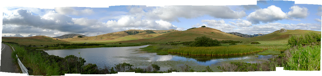
click to enlarge
Today’s thunder showers never materialized so I headed out toward Petaluma this afternoon. The image looking east on Nicasio Valley Rd. near the reservoir is made up of 12 vertically composed images stitched together using the “photomerge” tool in Adobe’s Photoshop CS3. The weather, the clouds, the light: it was jaw-droppingly beautiful!
On the Road……Town of Nicasio
What’s a trip to Nicasio without an image (or two) of the local church, some cows, and a hint of the baseball diamond in the middle of the town square?


