Archive for the ‘BICYCLING CALIFORNIA’ Category
On the Road……Southern Marin Bike Path

 Show on map
On the Road……Southern Marin Bike Path


On the Road……Fairfax Loop via Mill Valley and Panoramic Hwy

Bay Area on 12/05/09! Got to love the sunshine. And what a picture postcard vista.
You too can find the spot by clicking on the map link under the photo.
In the background are a few of the storied “seven sisters” — a series of beautiful rolling hills. Some are actually quite steep and not so rolling (see also here and here for a few more images of this stretch). I tend to get distracted by the scenery and want to get off my bike and have a little wine, cheese, dried fruit, or whatever else I’ve stowed in my big, roomy front handlebar bag!
On the Road……Fairfax Loop via Mill Valley and Panoramic

A Prius ad was being shot at the top of Bolinas Road and Ridgecrest.
Route Map……Fairfax-to-Mill Valley via Panoramic Hwy
On the Road……Panoramic Highway-to-Mill Valley

12/05/09: Current and former New York City Bicycle Club members Tania, John, and Carmen. Tania was in town for a visit. John and Carmen now live in SF. I did my best to keep up with these fast club riders during a very hilly 35-40 mile loop to and from Fairfax via Panoramic Highway and Mill Valley. (Here’s a map of the route.)
On the Road……Ridgecrest Blvd. to Mill Valley
Just a few miles in and Tania punctured her tire. A new tube and the ol’ ‘folded dollar bill between the tire and tube‘ trick to deal with the 1/4 inch tear in the sidewall.

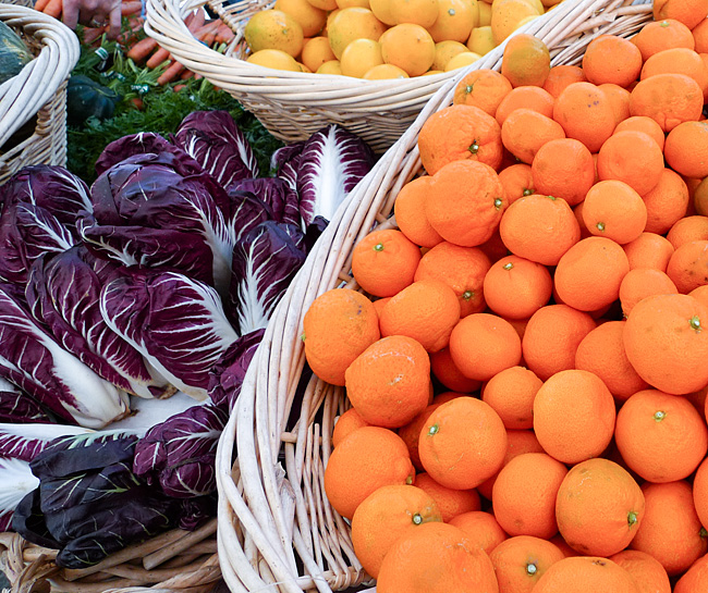
On the Road……Civic Center Farmer’s Market
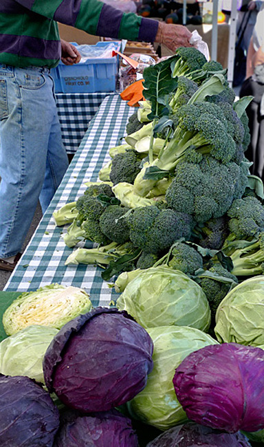
On the right, is an alternative version of this image. On the left…well…I just like the way the colors of the shirt match the vegetables. (Click on the images for a larger view.)
These images of the farmer’s market basking in sun from just a week ago are now but a distant memory after yesterday’s dusting of snow on Mt. Tamalpais (click here for some older posts and images of Mt. Tam).
Espresso Review……Reassessment

I’m not sure if The Friday Cyclotouriste will continue with full espresso reviews like this or this for two main reasons:
- Laziness. It’s a lot of data to collect. Plus, others (e.g. coffeeratings.com) are already doing in-depth reviews of local espresso and doing a very good job of it.
- Seeking the perfect espresso is often such an unrequited search that my reviews reflect the inevitable disappointment. (Lattes and cappuccinos are another matter — these seem to be the drinks that local roasters and baristas take the most pride in perfecting.)
I think I’ll just highlight espresso spots that are convenient for cyclists, continue to make images of these drinks, and offer some quick observations. I’ll reserve full reviews only for the rare and extraordinary experiences.
Route Map……Fairfax-to-San Rafael (Farmer’s Market)
A visit to the Civic Center farmer’s market in San Rafael (open every Thursday and Sunday year-round) makes for an enjoyable little 13 mile loop ride starting from Fairfax. Bring a bike with a large front basket for all your market goodies.
Riding to San Rafael (via San Anselmo) is straightforward. But upon entering San Rafael you must pick your way through downtown to Lincoln Ave. without the benefit of a dedicated bike lane. I usually cruise down 4th St. to Lincoln, which leads to a path that goes under Highway 101 and provides access to the Frank Lloyd Wright designed Civic Center.
The fun part of this ride is making it into a loop — something impossible in a car because there’s no road connecting the Terra Linda neighborhood of San Rafael with San Anselmo/Fairfax. But a narrow paved trail (at the end of Freitas Parkway) connects to the Sleepy Hollow neighborhood making this loop possible, provided you’re traveling by foot or bike.
This short-cut which starts around the 10-mile point is very steep (as you can see in the elevation profile), but relatively short (and I’m often tempted to walk the bike.)
On the Road……Civic Center Farmer’s Market

The amazing thing about the ballot victory at the polls last November — in addition to the north bay finally getting some fixed rail transit — is that the measure included full funding for a $91 million, 70-mile bike and pedestrian pathway stretching from Larkspur all the way to Cloverdale (70% of which is class 1 pathways, meaning bike/ped only — no cars)!
The beginnings of this infrastructure is visible in the image above.
(Full disclosure: I helped lobby for the ballot measure as the Marin Field Rep for Greenbelt Alliance). The Marin County Bicycle Coalition (MCBC) deserves tons of credit for their work spearheading the lobbying.
On the Road……Civic Center Farmer’s Market

The voter approved SMART train (which by 2014 will connect Sonoma and Marin cities to the Golden Gate Ferry in Larkspur) is taking shape .
This image was made on Lincoln Avenue in San Rafael going north toward the Civic Center with Highway 101 on the right. The train will enter downtown San Rafael in the concrete canyon wedged between these two roadways.
On the Road……Civic Center Farmer’s Market

The Japanese have a word to describe the blurred part of a photograph: it’s bokeh. Connoisseurs of fine lenses will actually debate the quality of the bokeh produced by different lenses.
I kind of like the bokeh in this shot.
On the Road……Civic Center Farmer’s Market

On the Road……Bolinas Ridge Climb

Click to embiggen
Riding back up the Bolinas ridge was a struggle.
The road climbs 1500′ in only four miles and as I described in my ride report the ‘man with the hammer’ was sneaking up on me. This pull-out along the serpentine road gave me an excuse to stop and rest, which turned out to be a brilliant idea! I ate half a sandwich and felt better.
The wikipedia bicycling glossary has this take on ‘the man with the hammer‘:
…a phrase that describes what happens to a rider who suddenly loses the ability to race, as in “The man with the hammer got him” or “He got hit by the man with hammer“. This is a reference to the experience boxers have when their legs become powerless and weak just before collapsing (as if they have been hit with a hammer) following a severe blow to the head. The abruptness with which this happens differentiates it from hitting the wall. Alternative expressions are “‘tapped'” short for “he got tapped by the man with hammer”.
Maybe it was the wall I avoided. Either way — hammer or wall — I needed rest and food.
On the Road……Bolinas Lagoon Meets Pacific Ocean

The turnaround point of my ride: the mouth of the Bolinas Lagoon.
(For a cool aerial perspective of this spot, click the geotag under the image then click the satellite map and zoom to taste!)
On the Road……Wharf Road, Bolinas

A small fishing boat moored off Wharf Road in downtown Bolinas
On the Road……Star Route Farms, Bolinas

Star Route Farms, one of the oldest organic farming operations in Marin. Founded by organic pioneer Warren Weber, a renaissance man who taught a Shakespeare course at UC Berkeley that I took when I was a grad student.
On the Road……Bolinas Lagoon, Eucalyptus Trees

A distinctive non-native species found all over rural Marin county. They grow like crazy, shed lots of leaves and bark, and have a really strong aroma. For me, they’re as familiar a part of the landscape as native Manzanita or Douglas fir.
On the Road……Bolinas’ Missing Highway Sign

Click to embiggen
Highway 1: looking across at the approximate spot where the sign signaling the way to Bolinas (to the left) would be standing if the locals didn’t keep tearing it down to discourage outsiders from visiting.
Route Map……Fairfax-to-Bolinas
On the Road……Egret, Bolinas Lagoon

A pesky cyclotouriste with a camera (now at sea level having descending from Bolinas ridge) causes a Snowy Great Egret to make haste.
On the Road……Looking Toward Bolinas

Over the ridge and heading toward the ocean, I’m treated to a glimpse of the Bolinas Lagoon, the Bolinas Mesa, and the Pacific Ocean (visible in that order from near to far).
On the Road……Approaching Ridge Crest

Nearing the ridgeline above Alpine Lake, Bolinas-Fairfax Rd. is about to intersect Ridgecrest Blvd. (hardly a Boulevard, in the traditional sense, look here for views of this so-called Boulevard).
Bear to the left to gain another 1000′ of elevation and to head toward the summit of Mt. Tamalpais (click here for some images from that ride) or bear to the right to lose 1500′ and descend to the Pacific Ocean and the town of Bolinas.
Bolinas is a famous haven for artists, writers, musicians, and philosophers and the first place I lived when my family moved to California from the mid-west.
Ride Report……Fairfax-to-Bolinas
The Bay Area is having a great Indian Summer. Temperatures nearing 70 degrees, negligible wind, and no fog.
A great excuse to ride out to the ocean: Fairfax to Bolinas (check out the route and elevation profile).
The summary:
The ride is about 35 miles round trip with roughly 4,000 feet of hills to climb. The first eight miles cover the route to Alpine Lake, but by continuing up and over Bolinas ridge down to the ocean you add another 2400′ of climbing (and 20 additional hard miles) to that round trip.
I left the house around 12:15pm, but turned around just after leaving to fetch my cheap, plastic windbreaker. For most of the day I wore just a lightweight merino wool t-shirt and a pair of wool knickers (from Bicycle Fixation) with a heavier long-sleeve wool pullover and the windbreaker in reserve.
Loaded for the day, the Ebisu is no lightweight and my largest rear cog has only 27 teeth. Suffice to say I suffered greatly climbing the 1500′ Bolinas ridge on the way back. The truth is, I’m just not in top cycling shape this season and these kind of climbs are serious work.
In terms of food I brought: 2 PB&Js, a honey crisp apple, a couple slices of Havarti cheese, and two water bottles. In hindsight, this was a bare minimum; I should have brought more.
On the way out to the ocean, I stopped briefly at Ridgecrest Blvd, but otherwise rode straight to the coast in less than two hours. Now quite hungry, I ate one of my sandwiches and the cheese. It was good I didn’t eat more, because I would need every remaining morsel for the return trip.
Climbing back up to Ridgecrest (after relaxing at the beach in downtown Bolinas for 20-30 minutes), I starting losing all my power and I could hear Velocio’s words inside my head (never ride to the point of exhaustion; eat before you are hungry, etc., etc.).
Discouraged, as I was within a mile of the top, I nevertheless got off my bike to avoid bonking. Dizzy and seeing spots (at this pullout), I ate an apple and half of my last PB&J (saving the final half a sandwich for the energy boost I’d need to climb the last hill of the ride before descending home into Fairfax). Within five minutes, I felt good enough to continue.
I was super stoked, however, that I brought that plastic windbreaker, because as I flew down Bolinas Rd. in total shade I was amazed how cold my body had become (despite the day starting off so sunny and warm). With the sun getting low, around 4:30pm, I slipped the plastic windbreaker over both wool layers on the final steep descent (which is 4 miles long and where speeds can exceed 35 mph) and was very, very happy…and when I arrived home: very, very tired.
On the Road……NO CAMPING, NO BOATS, NO SWIMMING…
…NO OPEN FIRES, so says MMWD. Still, you can always ride a bicycle or go for a hike via the nearby Cataract Trail. (p.s. thanks to the group from SF who shared water and some delicious grapes at this scenic little spot).

On the Road……Alpine Lake Redux
Just another beautiful northern California October day.

Ride Report……Alpine Lake, there and back
Because it’s so close to my house, this is my “3x a week, and it still never gets old” ride. It’s usually what I do when I don’t have a destination in mind, but am itching to get out on the bike.
The route can also be incorporated into other rides (a long loop out to the coast and Highway 1 or a Panoramic Highway-Central Marin loop)
If I want to build strength and go fast I’ll ride my Guerciotti. If I’m feeling a little lazy, I’ll load the Ebisu‘s big handlebar bag full of snacks (some olives, maybe a little salami and cheese, some watered down red wine, and an apple) and go at a more leisurely pace, adding mileage by exploring some of the fire roads around the lake.
What makes it so interesting is the variation and scenic beauty. During the roughly 17 mile round trip you’re almost always climbing or descending; it’s rarely flat. In fact, in the first 3 miles there’s nearly 1,000 feet of elevation gain. This is followed by a long descent and then several more (yet easier) climbs and descents all the way to the lake.
The road curves its way through the foothills of Mt. Tamalpais with only 2 or 3 straight stretches and the terrain you pass through includes Redwood forests, scenic overlooks, and lots of water at the end. Plus, there are few cars to contend with even on week-ends.
What’s not to love?
Check out here, here, here, and here for some images made along this roadway.
On the Road……The Inkwells, Lagunitas

On the Road……The Inkwells and the End of Summer

Once again the heat (mid-90’s F) kept me close to home. I rode out to this semi-secret swimming hole — the Inkwells as it’s known to locals. I met some hospitable folks and had a nice swim. The Geotag shows the location. Don’t tell, but do drop by for a swim if you’re pedaling out toward Pt. Reyes.
On the Road……Duxberry Reef, Bolinas

A preview of the ride I’m planning this week: Duxbury Reef tide pools.
I made these photos last December during a 2-hour window right before sundown.
On the Road……Santa Cruz, a few more photos

I wanted to bicycle out to the coast today, but a heat wave (103 degree F) made me rather lethargic. So here’s a few unpublished images from my recent Santa Cruz trip.
My brother (pictured) and I like this image because of its enigmatic time and geography: The Macedonian coastline, early 1960s perhaps.
For the actual location, remember to click the geotag icon below the image and use the zoom and map tools (switching to the satellite map type and zooming in very close is always interesting).
His bike is a really nice, old lugged Trek. That’s an Ostrich Bag on the front and a home-made pannier bag on the back.
On the Road……Santa Cruz

This is where your brussel sprouts come from……and the last bit of farmland before entering Santa Cruz (just past Wilder Ranch State Park).
One of my knees was really killing me at this point (and by killing me, I mean it felt like I was being stabbed in the knee with two screw drivers). I later discovered I had stupidly pedaled 100 miles on a saddle that was set too high. Lesson learned.
On the Road……Santa Cruz

The white sheen on the rocks? It’s guano, in case you were wondering.
On the Road……Mill Valley, Boot Coffee Consulting
This Friday’s ride was a short commute to Mill Valley and since I forgot my camera I’m including a map instead.
There are many possible routes using little side roads and bike paths, but these bike paths are not visible on Google maps, hence the gaps between the red route lines.
I left a little past 8am and rode at a slow, meandering pace for about an hour. My destination was an intensive specialty coffee training workshop with Willem J. Boot of Boot Coffee Consulting, a remarkable fellow with a true mastery of his subject. The state-of-the-art, teaching studio (equipped with numerous roasters and high-tech coffee industry gadgetry) is continuously abuzz with instructional exercises laid out in ritualistic fashion by Willem’s able associate, Jodi.
The class was also graced by a special guest, Graciano Cruz, of Los Lajones estates in Panama who spoke of his efforts to raise the quality level of coffee and with it the lives of the region’s indigenous farmers (see this description of his world class coffee).
Overall, it was a fantastic course during which I was treated to a cupping of the fabled Gesha coffee from Panama, as well as some delicious Ethiopian, Kenyan, Guatemalan, and Taiwanese (yes Taiwanese) samples. The location of the Boot Coffee school is marked by the southern most of the blue placemarks on the above map.
(Note: The Friday Cyclotouriste’s espresso reviews may need a complete overhaul now that my sensory awareness of coffee has been exposed to Mr. Boot and the SCAA and CQI criteria.)
The other placemarks on the map pinpoint two other highlights of this ride: (1) my closest encounter yet with a Red-Tailed Hawk (only about 20′ away sitting in a nearby tree) and (2) a voluminous patch of black berries that I stopped to gorge on during the evening ride home.
On the Road……Heading to Santa Cruz, Hwy 1

Looking northwest, past Devil’s Slide along Highway 1.
Espresso Review……Whale City Bakery, Davenport

SUMMARY (84 out of 100 points): Was it because of the 80+ miles of hard riding that preceded it or was this, in fact, a very good espresso in its own right? Separating the two is tricky (you know how everything tastes great when you’re out hiking or camping–same thing with a bike ride of this length).
I have to say I think Whale City Bakery gets much right with its espresso. The presentation was acceptable. The crema was decent though not stellar (a little thin actually), but the flavor really shined through. I’m not one that easily identifies the acidity or flavor attributes (like floral, citrus, malt, etc.) of each cup. Nonetheless, the overall taste just seemed right–clean, balanced, yet also interesting.
Because I was curious the Barista retrieved the foil bag of espresso—apparently a local Santa Cruz purveyor, whose name I unfortunately failed to make a note of and have now forgotten.
Taste (5/5)
Crema (4/5);
Serving size (4/5);
Presentation (4/5);
Eco-friendliness (4/5)
![]()
![]()
(If you haven’t already done so check out The Friday Cyclotouriste’s espresso rating system).
Ride Report……Heading To Santa Cruz, Part II

The route was prety straightforward. If you’re not familiar with the Bay Area you should print out some maps, but we basically made our way from memory.
The trip breaks down roughly into three sections.
Mile 0-35: a mix of urban and suburban roads and bike paths which wind through Marin cities such as San Anselmo, Ross, Corte Madera, and Sausalito. You cross the Golden Gate Bridge and head west toward the coast and climb Skyline Blvd. before enjoying a nice descent into the city of Pacifica.
Mile 35-50: the long climb outside of Pacifica past Devil’s Slide offers some spectacular coastal views on the descent. Then it’s mostly flat or gentle low rolling hills to Half Moon Bay (which is a good place to remember to eat something or at least stock up on food).
Mile 50-100: a lot of short steep hills in this section makes it difficult to maintain much momentum. Also there’s no running water at the numerous coastal campsites, but Pigeon Point Lighthouse will let you use their hose spigot to refill water bottles. A few miles past the lighthouse is Gazos Grill in Pescadero, which will serve you a meal. Then there’s Davenport (see my espresso review). Finally, in the last 14 miles or so, the hilliness decreases as you roll past fields planted with brussel sprouts and begin to hit the outskirts of Santa Cruz. We crossed town, mostly on bike paths, to arrive at our friend’s house near the boardwalk where we would stay for the night.
Note: the picture above is of my brother along the climb outside of Pacifica. It’s steeper than it looks, the shoulder is quite narrow, and there’s lots of truck traffic heading up to the construction project where a massive new tunnel is being built.
Read Part I here
On the Road……Heading South, Golden Gate Bridge

It may not look so, but it was foggy, cold, and very windy this morning. I was comfortable only after putting a windbreaker over two wool layers.
Also, we found out the bike path on the west side of the Golden Gate Bridge is closed during the week.
Whoops!
This made entering and exiting the bridge a little more complicated.
On the Road……Heading to Santa Cruz, Mill Valley

Since we didn’t eat breakfast. A picnic table by this Mill Valley park, 35 minutes into the ride, was our first stop.

